Wangaratta
|
Wangaratta Victoria |
|||||||
|---|---|---|---|---|---|---|---|

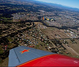
Aerial view from the north-west, Hume Freeway bypass somewhere around top, One and Three Mile creeks meeting around the middle.
|
|||||||
| Location in Victoria | |||||||
| Coordinates | 36°21′30″S 146°18′45″E / 36.35833°S 146.31250°ECoordinates: 36°21′30″S 146°18′45″E / 36.35833°S 146.31250°E | ||||||
| Population | 18,158 (2015) | ||||||
| • Density | 315.24/km2 (816.5/sq mi) | ||||||
| Area | 57.6 km2 (22.2 sq mi) (2011 urban) | ||||||
| Time zone | AEST (UTC+10) | ||||||
| • Summer (DST) | AEST (UTC+11) | ||||||
| Location | 250 km (155 mi) from Melbourne | ||||||
| LGA(s) | Rural City of Wangaratta | ||||||
| County | Moira, Delatite, Bogong | ||||||
| State electorate(s) | Ovens Valley | ||||||
| Federal Division(s) | Indi | ||||||
|
|||||||
Wangaratta (/wæŋɡəˈrætə/) is a cathedral city in the northeast of Victoria, Australia, approximately 250 km (160 mi) from Melbourne along the Hume Highway. The city had an estimated urban population of 18,158 at June 2015.
The city is located at the junction of the Ovens and King rivers, which drain the northwestern slopes of the Victorian Alps. Wangaratta is the administrative centre and the most populous city in the Rural City of Wangaratta local government area.
The original inhabitants of the area were the Pangerang peoples (Pallanganmiddang, WayWurru, Waveroo), who spoke a Gunai language. Many of the Pangerang were killed in the Gippsland massacres.
The first European explorers to pass through the Wangaratta area were Hume and Hovell (1824) who named the Oxley Plains immediately south of Wangaratta.Major Thomas Mitchell during his 1836 expedition he made a favourable report of its potential as grazing pasture. The first squatter to arrive was Thomas Rattray in 1838 who built a hut (on the site of the Sydney Hotel) founding a settlement known as "Ovens Crossing".
...
Wikipedia

