Wanborough, Surrey
| Wanborough | |
|---|---|
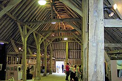
 The interior of the Great Barn, Wanborough |
|
 Barley growing in fields in Wanborough |
|
| Wanborough shown within Surrey | |
| Area | 7.57 km2 (2.92 sq mi) |
| Population | 335 (Civil Parish 2011) |
| • Density | 44/km2 (110/sq mi) |
| OS grid reference | SU934489 |
| District | |
| Shire county | |
| Region | |
| Country | England |
| Sovereign state | United Kingdom |
| Post town | Guildford |
| Postcode district | GU3 |
| Dialling code | 01483 |
| Police | Surrey |
| Fire | Surrey |
| Ambulance | South East Coast |
| EU Parliament | South East England |
| UK Parliament | |
Wanborough (/ˈwɒnbrᵿ/ or /ˈwɒnbərə/) is a rural village and civil parish in Surrey approximately 6 km west of Guildford on the northern slopes of the Hog's Back. Wanborough lies between Puttenham and Normandy which includes the larger community around Wanborough railway station named Flexford. Wanborough grew around and to service Wanborough Manor which is on the site of ancient springs.
According to a local publication Wanborough and its Church, humans in prehistory travelled along the Hog's Back, attracted by the spring in the locality. The earliest settlement dates to 8000 BC.
The "Wanborough Coins" are part of a votive offering deposited at a Romano-Celtic temple (i.e., late 1st century BC to 4th century AD); this site was looted between 1983 and 1985, but over one thousand silver coins, a small part of the original assemblage, were eventually added to the collection of the British Museum. The British Museum calls the destruction of the Romano-Celtic temple at Wanborough in Surrey 'one of the saddest stories in British archaeology'.
A headdress and sceptre handles were also recovered. These were probably used by a priest during rituals. Subsequent excavations have shown that there were in fact two temples on the site. A circular temple had been built during the late first century BC, replaced in the second century AD by a square temple.
...
Wikipedia

