Walters, OK
| Walters, Oklahoma | |
|---|---|
| City | |

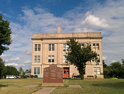
Cotton County Courthouse in 2014
|
|
| Motto: "Small town; Big heart" | |
 Location of Walters, Oklahoma |
|
| Coordinates: 34°21′23″N 98°18′57″W / 34.35639°N 98.31583°WCoordinates: 34°21′23″N 98°18′57″W / 34.35639°N 98.31583°W | |
| Country | United States |
| State | Oklahoma |
| County | Cotton |
| Area | |
| • Total | 8.4 sq mi (21.7 km2) |
| • Land | 8.1 sq mi (21.1 km2) |
| • Water | 0.2 sq mi (0.6 km2) |
| Elevation | 1,001 ft (305 m) |
| Population (2010) | |
| • Total | 2,551 |
| • Density | 314.9/sq mi (120.9/km2) |
| Time zone | Central (CST) (UTC-6) |
| • Summer (DST) | CDT (UTC-5) |
| ZIP code | 73572 |
| Area code(s) | 580 |
| FIPS code | 40-78150 |
| GNIS feature ID | 1099338 |
Walters is a town in Cotton County, Oklahoma, United States. The population was 2,551 at the 2010 census. The city, nestled in between twin creeks, is the county seat of Cotton County. The city's motto is "Small town; Big heart."
The land that is present-day Oklahoma was first settled by prehistoric American Indians including the Clovis 11500 BCE, Folsom 10600 BCE and Plainview 10000 BCE cultures. Western explorers came to the region in the 16th century, with Spanish explorer Francisco Vásquez de Coronado visiting in 1541. Most of the region during this time was settled by the Wichita and Caddo peoples. Around the 1700s, two tribes from the North, the Comanches and Kiowas, migrated to the Oklahoma and Texas region.
For most of the 18th century, the Oklahoma region was under French control as part of Louisiana. In 1803, the Louisiana Purchase by Thomas Jefferson brought the area under United States control. In 1830, Congress passed the Indian Removal Act, which removed American Indian tribes and relocated them to Indian Territory. The southern part of the territory was originally assigned to the Choctaw and Chickasaw, until the 1867 Medicine Lodge Treaty allotted the southwest portion of the Choctaw and Chickasaw’s lands to the Comanche, Kiowa, and Apache.
...
Wikipedia
