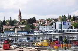
Wallisellen
| Wallisellen | ||
|---|---|---|
 |
||
|
||
| Coordinates: 47°25′N 8°36′E / 47.417°N 8.600°ECoordinates: 47°25′N 8°36′E / 47.417°N 8.600°E | ||
| Country | Switzerland | |
| Canton | Zürich | |
| District | Bülach | |
| Area | ||
| • Total | 6.43 km2 (2.48 sq mi) | |
| Elevation | 431 m (1,414 ft) | |
| Population (Dec 2015) | ||
| • Total | 15,603 | |
| • Density | 2,400/km2 (6,300/sq mi) | |
| Postal code | 8304 | |
| SFOS number | 0069 | |
| Surrounded by | Dietlikon, Dübendorf, Kloten, Opfikon, Zürich | |
| Twin towns | Rolle (Switzerland) | |
| Website |
www SFSO statistics |
|
Wallisellen is a municipality in the district of Bülach in the canton of Zürich in Switzerland, and belongs to the Glatt Valley (German: Glattal).
The first settlement at Wallisellen dates from 58 BC. The municipality Wallisellen has its origin between 400 and 700 BC, after the Germanic migration of the peoples. Wallisellen is named according to both parts "Walchen" and "Seller". The Germanic peoples described as «Walchen» its Celtic and romanic neighbours (look at Walensee Lake of the Walchen). The word "Seller" stands for immigrated farmers, in contrast to long-established farmers, who cultivated small and modest farm. Linguists think that name comes along because Franks or Alemanni gave the name "Wallisellen" to a small farmer settlement, which was inhabited or founded from Celts or Romans.
In 1916, the municipality of Rieden merged with Wallisellen.
With inauguration of the NOB-line Zürich–Wallisellen–Winterthur on 25 June 1856 Wallisellen had its first connexion with the Swiss railway network. In 1916, the municipality of Rieden merged with Wallisellen. In interwar period Wallisellen developed from a village to a growing suburb-municipality of Zurich, but didn't want to have town charter.
During Second World War, Wallisellen took part hugely in the "Anbauschlacht" ("cultivation battle", i.e. increase in domestic food production due to reductions in imports) (Plan Wahlen). In 1958 the Roman Catholic church of St. Antonius was built.
Wallisellen has an area of 6.5 km2 (2.5 sq mi). Of this area, 23.8% is used for agricultural purposes, while 20.1% is forested. Of the rest of the land, 54.5% is settled (buildings or roads) and the remainder (1.5%) is non-productive (rivers, glaciers or mountains).
Wallisellen has a population (as of 31 December 2015) of 15,603. As of 2007[update], 25.5% of the population was made up of foreign nationals. Over the last 10 years the population has grown at a rate of 11.8%. Most of the population (as of 2000[update]) speaks German (83.2%), with Italian being second most common ( 3.8%) and Serbo-Croatian being third ( 1.9%).
...
Wikipedia


