Wakefield-Peacedale, Rhode Island
| Wakefield-Peacedale, Rhode Island | |
|---|---|
| CDP | |
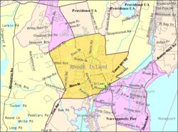
 Map of Wakefield-Peacedale with its boundaries in 2000 |
|
| Coordinates: 41°26′28″N 71°29′57″W / 41.44111°N 71.49917°WCoordinates: 41°26′28″N 71°29′57″W / 41.44111°N 71.49917°W | |
| Country | United States |
| State | Rhode Island |
| County | Washington |
| Area | |
| • Total | 5.1 sq mi (13.2 km2) |
| • Land | 4.9 sq mi (12.6 km2) |
| • Water | 0.2 sq mi (0.6 km2) |
| Population (2010) | |
| • Total | 8,487 |
| • Density | 1,739.4/sq mi (671.6/km2) |
| Time zone | Eastern (EST) (UTC-5) |
| • Summer (DST) | EDT (UTC-4) |
| FIPS code | 44-73130 |
Wakefield-Peacedale is a census-designated place (CDP) in the town of South Kingstown in Washington County, Rhode Island, United States that includes the villages of Peace Dale and Wakefield. The population was 8,468 at the 2000 census.
Wakefield-Peacedale is located at 41°26′28″N 71°29′57″W / 41.44111°N 71.49917°W (41.441234, -71.499290).
According to the United States Census Bureau, the CDP has a total area of 5.1 mi² (13.2 km²). 4.9 mi² (12.6 km²) of it is land and 0.2 mi² (0.6 ²) (4.70%) is water.
At the 2000 census, there were 8,468 people, 3,221 households and 2,174 families residing in the CDP. The population density was 671.4/km² (1,739.4/mi²). There were 3,385 housing units at an average density of 268.4/km² (695.3/mi²). The racial makeup of the CDP was 90.34% White, 2.01% African American, 3.08% Native American, 1.23% Asian, 0.56% from other races, and 2.79% from two or more races. Hispanic or Latino of any race were 1.56% of the population.
...
Wikipedia
