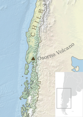
Volcán Osorno
| Osorno | |
|---|---|

Osorno in 1993
|
|
| Highest point | |
| Elevation | 2,652 m (8,701 ft) |
| Coordinates | 41°06′00″S 72°29′35″W / 41.10000°S 72.49306°W |
| Geography | |
| Location | Chile |
| Parent range | Andes |
| Geology | |
| Mountain type | Stratovolcano |
| Volcanic arc/belt | South Volcanic Zone |
| Last eruption | 1869 |
| Climbing | |
| First ascent | 1848 by Jean Renous |
| Easiest route | rock/snow/ice climb |
Osorno Volcano is a 2,652-metre (8,701 ft) tall conical stratovolcano lying between Osorno Province and Llanquihue Province, in Los Lagos Region of Chile. It stands on the southeastern shore of Llanquihue Lake, and also towers over Todos los Santos Lake. Osorno is known worldwide as a symbol of the local landscape, and is noted for its similar appearance to Mount Fuji.
Osorno is one of the most active volcanoes of the southern Chilean Andes, with 11 historical eruptions recorded between 1575 and 1869. The basalt and andesite lava flows generated during these eruptions reached both Llanquihue and Todos los Santos Lakes. The upper slopes of the volcano are almost entirely covered in glaciers despite its very modest altitude and latitude, sustained by the substantial snowfall in the very moist maritime climate of the region.
Osorno sits on top of a 250,000-year-old eroded stratovolcano, La Picada, with a 6-km-wide caldera.
Petrohué Waterfalls (Saltos del Petrohué) with Osorno volcano in the background.
Ski La Burbuja, Osorno Volcano.
Osorno Volcano from Petrohué Harbor.
Sun setting behind the peak, highlighting the drifting snow.
The "Red Crater" on the slopes of Osorno (a "flank crater").
Osorno in front of the Petrohué Waterfalls.
Osorno Volcano and Petrohué Waterfalls.
...
Wikipedia

