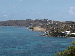
Virgin Gorda Airport
| Virgin Gorda Airport | |||||||||||
|---|---|---|---|---|---|---|---|---|---|---|---|
 |
|||||||||||
| Summary | |||||||||||
| Airport type | Public | ||||||||||
| Operator | BVIAA | ||||||||||
| Serves | Spanish Town, Virgin Gorda | ||||||||||
| Location | British Virgin Islands | ||||||||||
| Elevation AMSL | 14 ft / 4 m | ||||||||||
| Coordinates | 18°26′44″N 64°25′41″W / 18.44556°N 64.42806°WCoordinates: 18°26′44″N 64°25′41″W / 18.44556°N 64.42806°W | ||||||||||
| Map | |||||||||||
| Location in the British Virgin Islands | |||||||||||
| Runways | |||||||||||
|
|||||||||||
|
Source: DAFIF
|
|||||||||||
Virgin Gorda Airport (IATA: VIJ, ICAO: TUPW) is an airport on Virgin Gorda in the British Virgin Islands, an overseas territory of the United Kingdom.
Historically, Virgin Gorda was served in the past by American Eagle with this service being operated by Executive Airlines on behalf of American Airlines from San Juan (SJU). This regional air carrier became a wholly owned subsidiary of American Airlines and flew CASA 212-200 twin turboprop aircraft into the airport. Sunaire flying as Eastern Express on behalf of Eastern Airlines via a code sharing agreement served Virgin Gorda as well. This wholly owned subsidiary of Metro Airlines operated de Havilland Canada DHC-6 Twin Otter STOL (short take off and landing) turboprop aircraft. Island Birds Air Charter, having served Virgin Gorda since the year 2000, currently operates the largest, unrestricted aircraft permitted at the airfield.
The airport is owned and operated by the Government of the VI (UK). The government purchased the airport from Little Dix Bay Resort for $2.9 million in 2005.
The runway at the airport remains an unpaved, sand and gravel airstrip. In January, 2010 the airport was closed for major construction work. It reopened in December, 2010 with Limitations and Restrictions put in place by the ASSI regulatory agency. It is currently restricted to a small handful of airlines that must be fully approved by both ASSI and the FAA to operate at the field.
...
Wikipedia

