Vieques
| Vieques, Puerto Rico | |||
|---|---|---|---|
| Municipality | |||

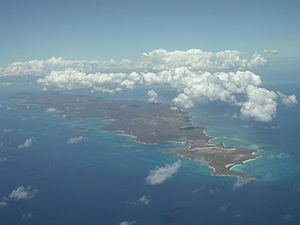
Vieques from the air, looking west
|
|||
|
|||
| Nickname(s): Isla Nena | |||
 Location of Vieques in Puerto Rico |
|||
| Coordinates: 18°07′N 65°25′W / 18.117°N 65.417°WCoordinates: 18°07′N 65°25′W / 18.117°N 65.417°W | |||
| Country | United States | ||
| Territory | Puerto Rico | ||
| Government | |||
| • Mayor | Víctor Emeric (PPD) | ||
| • Senatorial District | 8 - Carolina | ||
| • Representative District | 36 | ||
| Area | |||
| • Total | 134.42 sq mi (348.15 km2) | ||
| • Land | 52 sq mi (135 km2) | ||
| • Water | 82.30 sq mi (213.15 km2) | ||
| Population (2010) | |||
| • Total | 9,301 | ||
| • Density | 69/sq mi (27/km2) | ||
| Demonym(s) | Viequenses | ||
| Racial groups | |||
| • White | 72.7% | ||
| • Black | 13.8% | ||
| • American Indian/AN | 0.4% | ||
| • Asian - Native Hawaiian/Pi |
0.6% 0.8% |
||
| • Other Two or more races |
8.8% 3.4% |
||
| Time zone | AST (UTC-4) | ||
| Zip code | 00765 | ||
Vieques (/viːˈeɪkᵻs/; Spanish pronunciation: [ˈbjekes], locally: [ˈbjẽke]), in full Isla de Vieques, is an island–municipality of Puerto Rico in the northeastern Caribbean, part of an island grouping sometimes known as the Spanish Virgin Islands. Vieques is part of the Commonwealth of Puerto Rico, and retains strong influences from 400 years of Spanish presence in the island.
Vieques lies about 8 miles (13 km) east of the Puerto Rican mainland, and measures about 21 miles (34 km) long by 4 miles (6 km) wide. Its most populated barrio Isabel Segunda (sometimes written "Isabel II"), the administrative center on the northern side of the island. The population of Vieques was 9,301 at the 2010 Census.
The island's name is a Spanish spelling of an American Indian word (likely Taíno) said to mean "small island". It also has the nickname "Isla Nena", usually translated from the Spanish as "Little Girl Island", alluding to its perception as Puerto Rico's little sister. During the colonial period, the British name was "Crab Island".
Vieques is best known internationally as the site of a series of protests against the United States Navy's use of the island as a bombing range and testing ground, which led to the navy's departure in 2003. Today the former navy land is a national wildlife refuge, with numerous beaches that still retain the names given by the navy, including Red Beach, Blue Beach and Green Beach. The beaches are commonly listed among the top beaches in the Caribbean for their azure-colored waters and white sands.
...
Wikipedia


