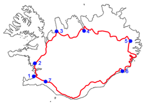
Vesturlandsvegur
| Route 1 | |
|---|---|
| Þjóðvegur 1 | |

|
|
| Route information | |
| Length: | 1,332 km (828 mi) |
| Highway system | |
| National Roads in Iceland | |
Route 1 or the Ring Road (Icelandic: Þjóðvegur 1 or Hringvegur) is a national road in Iceland that runs around the island and connects most of the inhabited parts of the country. The total length of the road is 1,332 kilometres (828 mi). Some of the most popular tourist attractions in Iceland, such as the Seljalandsfoss and Skógafoss waterfalls, Dyrhólaey and the Jökulsárlón glacier lagoon, are by the Ring Road.
The ring was completed in 1974, coinciding with the 1,100th anniversary of the country's settlement when the longest bridge in Iceland, crossing the Skeiðará river in the southeast, was opened.
For almost all its length, the road is two lanes wide: one lane going in each direction. Where it passes through larger towns, the number of lanes may be increased, as it also is in the Hvalfjörður Tunnel. Many smaller bridges are single lane, especially in eastern Iceland, and are constructed of wood or steel. The road is paved with asphalt for most of its length, but there are still stretches in eastern Iceland with unpaved gravel surfaces. The Iceland Road Administration, Vegagerðin, oversees the maintenance and building of both main roads and minor roads.
Some portions of the road are still original 1940s country roads, and contain potential hazards such as blind curves and blind summits, single lane bridges or narrow passes. In winter, icy roads and strong winds, 15 m/s for cars with trailers, 25 m/s for cars without trailers, can make travel hazardous. Currently, 32 km out of the 1,332 km are unpaved.
...
Wikipedia

