Vermejo Park Ranch
| Vermejo Park Ranch | |
|---|---|
| Private Ranch | |

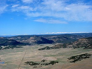
Vermejo Park Ranch, looking west towards Valle Vidal. The ranch includes land from the Great Plains in the foreground to the snow-capped Sangre de Cristo Mountains in the background, February 2011.
|
|
| Location of main office | |
| Coordinates: 36°51′46″N 104°28′24″W / 36.86278°N 104.47333°WCoordinates: 36°51′46″N 104°28′24″W / 36.86278°N 104.47333°W | |
| Country | United States |
| State | New Mexico |
| County | Colfax / Taos counties, New Mexico and Las Animas / Costilla counties, Colorado, USA |
| Area | |
| • Total | 923 sq mi (2,390 km2) |
| Time zone | MST (UTC-7) |
| • Summer (DST) | MDT (UTC-6) |
| Owner | Ted Turner |
| Coordinates are for the address: 1 York Canyon, Raton NM 87740 | |
The Vermejo Park Ranch is a 590,823-acre (239,098 ha) ranch owned by Ted Turner in northeastern New Mexico and southern Colorado. The ranch is about 3/4 the size of the State of Rhode Island. The ranch, which stretches from the Great Plains to the summit of the Sangre de Cristo Mountains, is used primarily for conservation, hunting, fishing, and other recreation, but also produces significant quantities of coalbed methane, a type of natural gas.
The Vermejo Park Ranch, located just west of the city of Raton, is the biggest component of Turner's ranch empire of 2,000,000 acres (810,000 ha) that made him the second biggest private landowner in the United States as of 2012. It lies mostly in western Colfax County, New Mexico, but smaller portions extend into northeastern Taos County, New Mexico as well as southwestern Las Animas County and southeastern Costilla County in Colorado.
Elevations of Vermejo Park ranch range from 5,850 feet on the Canadian River near Maxwell, New Mexico to Big Costilla Peak which rises to 12,931 feet (3,941 m) on the western boundary of the ranch and the border between New Mexico and Colorado. Most of the ranch consists of the Park Plateau, part of the Raton Basin, a much dissected tableland with elevations from 6,500 feet (2,000 m) to about 9,000 feet (2,700 m) The westernmost extension of the ranch is in the Sangre de Cristo Mountains with elevations from 9,000 feet (2,700 m) to above timberline. An eight-mile long, north-south ridge with four summits above 12,750 feet (3,890 m) including Big Costilla Peak form the western boundary of the ranch .
...
Wikipedia

