Veradale, Washington
| Veradale, Washington | |
|---|---|
| CDP | |
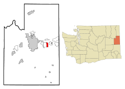
 Location of Veradale, Washington |
|
| Location of Veradale, Washington | |
| Coordinates: 47°39′1″N 117°12′32″W / 47.65028°N 117.20889°WCoordinates: 47°39′1″N 117°12′32″W / 47.65028°N 117.20889°W | |
| Country | United States |
| State | Washington |
| County | Spokane |
| Area | |
| • Total | 3.1 sq mi (8.0 km2) |
| • Land | 3.1 sq mi (8.0 km2) |
| • Water | 0.0 sq mi (0.0 km2) |
| Elevation | 2,024 ft (617 m) |
| Population (2000) | |
| • Total | 9,387 |
| • Density | 3,042.3/sq mi (1,174.6/km2) |
| Time zone | Pacific (PST) (UTC-8) |
| • Summer (DST) | PDT (UTC-7) |
| ZIP code | 99037 |
| Area code | 509 |
| FIPS code | 53-74725 |
| GNIS feature ID | 1512761 |
Veradale is a former census-designated place (CDP) in Spokane County, Washington, United States. The population was 9,387 at the 2000 census. Veradale was named for Vera McDonald, the daughter of the man who founded the community in 1911. Since 2003, the area has been incorporated as part of the city of Spokane Valley.
Veradale is located at 47°39′1″N 117°12′32″W / 47.65028°N 117.20889°W (47.650195, -117.208937).
According to the United States Census Bureau, the CDP has a total area of 3.1 sq mi (8.0 km2), all of it land.
The following diagram represents the locations in a radius of 5.0 miles (8.0 km) around Veradale.
As of the census of 2000, there were 9,387 people, 3,317 households, and 2,540 families residing in the CDP. The population density was 3,042.3 people per square mile (1,172.9/km²). There were 3,440 housing units at an average density of 1,114.9/sq mi (429.8/km²). The racial makeup of the CDP was 93.94% White, 1.05% African American, 0.79% Native American, 1.87% Asian, 0.05% Pacific Islander, 0.49% from other races, and 1.80% from two or more races. Hispanic or Latino of any race were 2.32% of the population.
...
Wikipedia

