Vega Baja
| Vega Baja, Puerto Rico | ||
|---|---|---|
| Municipality | ||
|
||
| Nickname(s): Ciudad del "Melao Melao" | ||
| Anthem: "Más dulce que la miel es tu recuerdo" | ||
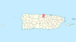
 Location of Vega Baja in Puerto Rico |
||
| Coordinates: 18°26′46″N 66°23′15″W / 18.44611°N 66.38750°WCoordinates: 18°26′46″N 66°23′15″W / 18.44611°N 66.38750°W | ||
| Country | United States | |
| Territory | Puerto Rico | |
| Founded | October 7, 1776 | |
| Government | ||
| • Mayor | Marcos Cruz Molina (Partido Popular Democrático) | |
| • Senatorial dist. | 3 - Arecibo | |
| • Representative dist. | 12 | |
| Area | ||
| • Total | 55.71 sq mi (144.28 km2) | |
| • Land | 47 sq mi (122 km2) | |
| • Water | 8.60 sq mi (22.28 km2) | |
| Population (2010) | ||
| • Total | 59,662 | |
| • Density | 1,100/sq mi (410/km2) | |
| Demonym(s) | Vegabajeños | |
| Time zone | AST (UTC-4) | |
| Zip code | 00693, 00694 | |
Vega Baja (Spanish pronunciation: [ˈbeɣa ˈβaxa], Lower Riverplain) is a municipality in north central Puerto Rico located in the northern coast, north of Morovis; east of Manatí; and west of Vega Alta. Vega Baja is spread over 13 wards and Vega Baja Pueblo (The downtown area and the administrative center of the city). It is part of the San Juan-Caguas-Guaynabo Metropolitan Statistical Area.
The name Vega Baja in Spanish means "low plains" Geographically, the North of Puerto Rico goes down lower or slighly higher than the level of the Atlantic Ocean and Vega Baja is a coastal town. Other historians believed that as Vega Baja comes from "La Vega" and Vega is a last name of one of the families that were originally in the foundation of Vega Baja, they took it to name the land. It is also believed that the name comes from the region of Spain "La Vega Baja del Segura". Although is generally believed that Vega Baja was founded on 1776, after the division of Vega Alta from La Vega historians have verified that it was many years after that the Spanish Government officially recognized it. The day of foundation generally accepted is October 7 since it is the commemoration of the "Virgin of the Rosary" and Vega Baja was originally known as "Vega-baxa del Naranjal de Nuestra Señora del Rosario (Vega Baja of the Orange of Our Lady of the Rosary)". Orange comes from its previous name based in the fruit that was cultivated in the place.
"Cibuco", name of one of the rivers that carve its fertile lands, is a variation of the name "Sebuco", a chief or Cacique Taíno Indian of the region. These "cells" of Taíno Indians were known to settle in the vicinity of the rivers. Although the Cibuco river is prone to floods due to heavy seasonal rains even to this day, the benefits provided to the land by the river are numerous.
Taino carvings have been found on some of the exposed reefs in the vicinity of the Cibuco river. Among these carvings, one depicting a face and others shaped as fish. They are an indication that these reefs were frequented for spear fishing and perhaps other day-to-day activities. Other places like Carmelita, Maisabel, Cueva Maldita and Paso del Indio are known as archaeological sites where the aborigins established their communities.
...
Wikipedia

