Van Nuys, California
| Van Nuys | |
|---|---|
| Neighborhood of Los Angeles | |

Valley Municipal Building in Van Nuys
|
|
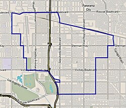
 Boundaries of Van Nuys as drawn by the Los Angeles Times |
|
| Location within Los Angeles and the San Fernando Valley | |
| Coordinates: 34°11′12.02″N 118°26′55.47″W / 34.1866722°N 118.4487417°W | |
| Country | United States |
| State | California |
| County | Los Angeles |
| City | Los Angeles |
| Named for | Real estate developer Isaac Newton Van Nuys |
| Elevation | 712 ft (217 m) |
| Population (2000) | |
| • Total | 136,443 |
| Time zone | PST (UTC-8) |
| • Summer (DST) | PDT (UTC-7) |
| ZIP code | 91401, 91405, 91406, 91409, 91411 |
| Area code(s) | 747, 818 |
Van Nuys /vænˈnaɪz/ is a neighborhood in the central San Fernando Valley region of the city of Los Angeles, California.
The town was founded in 1911, and named for Isaac Newton Van Nuys, one of its developers. It was annexed by Los Angeles on May 22, 1915, after completion of the Los Angeles Aqueduct, providing it with the water required for further growth. Van Nuys was the first new stop on the San Fernando Line of the Pacific Electric Railway red cars system, which boosted its early land sales and commercial success.
Van Nuys became the Valley's satellite Los Angeles municipal civic center, with the 1932 Art Deco Valley Municipal Building (Van Nuys City Hall), a visual landmark and Los Angeles Historic-Cultural Monument starting the present day Government Center complex of government services buildings.
In 1991 Marvin Braude, a member of the Los Angeles City Council, redesignated a 45-block area from being a part of Van Nuys to being a part of Sherman Oaks. This redesignated area included the community of Magnolia Woods. Some area residents had presented a petition and several original deeds that stated "Sherman Oaks" to Braude. They argued that the area was originally a part of Sherman Oaks until the 1960s, when ZIP codes labeling the area as Van Nuys were established.
...
Wikipedia

