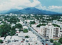
Valledupar, Cesar
| Valledupar | |||
|---|---|---|---|
| City and municipality | |||

View of the Downtown's 9th Avenue
|
|||
|
|||
| Nickname(s): City of the Holy Kings of Valledupar | |||
 Location in the Department of Cesar. Municipality (dark gray), City (red). |
|||
| Location within Colombia | |||
| Coordinates: 10°29′N 73°15′W / 10.483°N 73.250°WCoordinates: 10°29′N 73°15′W / 10.483°N 73.250°W | |||
| Country | Colombia | ||
| Region | Caribbean | ||
| Department | Cesar | ||
| Foundation | January 6, 1550 | ||
| Government | |||
| • Mayor | Fredys Socarras (Si Podemos (Independent)) | ||
| Area | |||
| • City and municipality | 4,977.66 km2 (1,921.89 sq mi) | ||
| Elevation | 180 m (590 ft) | ||
| Population (2005) | |||
| • City and municipality | 423,260 | ||
| • Density | 85/km2 (220/sq mi) | ||
| • Urban | 336,731 | ||
| Demonym(s) | Valduparense or Vallenato | ||
| Time zone | Eastern Time Zone (UTC-05) | ||
| Postal code | 200001-200005 | ||
| Area code(s) | 57 + 5 | ||
| Website | Official website (in Spanish) | ||
| *Valledupar metropolitan area is yet to be determined. | |||
Valledupar is a city and municipality in northeastern Colombia. It is the capital of Cesar Department. Its name, Valle de Upar (Valley of Upar), was established in honor of the Amerindian cacique who ruled the valley; Cacique Upar. The city lies between the mountains of Sierra Nevada de Santa Marta and the Serranía del Perijá to the borders of the Guatapurí and Cesar rivers.
Valledupar is an important agricultural, cattle raising, coal mining and agro-industrial center for the region between the Departments of Cesar and southern municipalities of La Guajira Department, formerly known as the Padilla Province. Valledupar is notable as the cradle of vallenato music, representative of the Colombian culture. The city hosts the Vallenato Legend Festival.
During the 1980s, 1990s and early 2000s, the city suffered during the Colombian Armed Conflict, with numerous kidnappings, thousands of people forced out and failure to control crime.
Valledupar has one of Colombia's most modern maximum security prisons.
The municipality of Valledupar is located southeast of the Sierra Nevada de Santa Marta, 10 degrees, 29 minutes, of north latitude and 73 degrees 15 minutes longitude to the west of the Greenwich Meridian. Valledupar's average temperature is about 28 °C. Because of its high altitude but proximity to the equator, this municipality possesses a variety of environments, from warm heat to perpetual snow. The most important heights are the Sierra Nevada de Santa Marta's peaks; the Codazzi, El Guardian, the Ojeda and La Reina. Many rivers descend from its snowy peaks and lagoons; the Ariguani, Ariguanicito, Badillo, Calderas, Cesar, Curiba, Donachui, Garupal, Guatapuri, which borders the city of Valledupar; and the Mariangola.
...
Wikipedia


