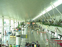
Val de Cães International Airport
|
Belém/Val-de-Cans–Júlio Cezar Ribeiro International Airport Aeroporto Internacional de Belém/Val de Cans–Júlio Cezar Ribeiro |
|||||||||||||||
|---|---|---|---|---|---|---|---|---|---|---|---|---|---|---|---|
 |
|||||||||||||||
| Summary | |||||||||||||||
| Airport type | Public/Military | ||||||||||||||
| Operator | Infraero | ||||||||||||||
| Serves | Belém | ||||||||||||||
| Elevation AMSL | 17 m / 56 ft | ||||||||||||||
| Coordinates | 01°23′05″S 048°28′44″W / 1.38472°S 48.47889°WCoordinates: 01°23′05″S 048°28′44″W / 1.38472°S 48.47889°W | ||||||||||||||
| Website | Infraero BEL | ||||||||||||||
| Map | |||||||||||||||
| Location in Brazil | |||||||||||||||
| Runways | |||||||||||||||
|
|||||||||||||||
| Statistics (2015) | |||||||||||||||
|
|||||||||||||||
|
Statistics: Infraero
Sources: Airport Website,ANAC |
|||||||||||||||
| Passengers | 3,714,761 |
|---|---|
| Aircraft Operations | 51,639 |
| Metric tonnes of cargo | 24,459 |
Belém/Val de Cans–Júlio Cezar Ribeiro International Airport (IATA: BEL, ICAO: SBBE) is the main airport serving Belém, Brazil. Val de Cans (sometimes spelled Val de Cães) is the name of the neighborhood where the airport is located. Since 13 April 2010 the airport is named also after (1837–1887) a researcher of balloons.
It is operated by Infraero.
Some of its facilities are shared with Belém Air Force Base of the Brazilian Air Force.
In 1934 General Eurico Gaspar Dutra, then the Director of the Military Aviation, appointed Lieutenant Armando Sierra de Menezes to choose in Val de Cans a site where an airport was to be built. The Directorate of Civil Aeronautics, an agency of the Ministry of Traffic and Public Works, would be in charge of the work. Val de Cans began its history as land track running along the east/west axis with 1,200m. The facility comprised a courtyard, a hangar and a parking structure of concrete for military aircraft, which later became known as "Yellow Hangar."
With the outbreak of World War II air bases and airports located on the Brazilian coast became immensely important in the support of transportation of aircraft, personnel and equipment across the South Atlantic Ocean to Sierra Leone in West Africa. These facilities provided the necessary logistical support for the thousands of planes that, manufactured in Canada and the United States were moved to North Africa and Europe. After protracted negotiations between Brazil and the United States, airstrips were built at Belém for the Air Transport Command with two runways measuring 1,500 x 45 meters on a basis of concrete and asphalt and comprising modern airport facilities, able to meet efficiently civil aviation and military needs. Val de Cans and other air bases used by the Americans during World War II were returned to the Ministry of Aeronautics in 1945.
...
Wikipedia

