Val-de-Travers
| Val-de-Travers | ||
|---|---|---|
 |
||
|
||
| Coordinates: 46°54′N 6°36′E / 46.900°N 6.600°ECoordinates: 46°54′N 6°36′E / 46.900°N 6.600°E | ||
| Country | Switzerland | |
| Canton | Neuchâtel | |
| District | Val-de-Travers | |
| Area | ||
| • Total | 124.91 km2 (48.23 sq mi) | |
| Elevation | 737 m (2,418 ft) | |
| Population (Dec 2015) | ||
| • Total | 10,905 | |
| • Density | 87/km2 (230/sq mi) | |
| Postal code | 2112 | |
| SFOS number | 6512 | |
| Website |
www SFSO statistics |
|
Val-de-Travers is a municipality in the district of Val-de-Travers in the canton of Neuchâtel in Switzerland. It was created on 1 January 2009, when the former municipalities of Boveresse, Buttes, Couvet, Fleurier, Les Bayards, Môtiers, Noiraigue, Saint-Sulpice and Travers merged to form Val-de-Travers.
The region is known for its production of absinthe.
Val-de-Travers is first mentioned in 1150 as Vallis traversis.
Val-de-Travers has an area, as of 2009[update], of 124.9 square kilometers (48.2 sq mi). Of this area, 52.92 km2 (20.43 sq mi) or 42.4% is used for agricultural purposes, while 63.24 km2 (24.42 sq mi) or 50.6% is forested. Of the rest of the land, 7.54 km2 (2.91 sq mi) or 6.0% is settled (buildings or roads), 0.59 km2 (0.23 sq mi) or 0.5% is either rivers or lakes and 0.39 km2 (0.15 sq mi) or 0.3% is unproductive land.
Of the built up area, housing and buildings made up 2.5% and transportation infrastructure made up 2.5%. Out of the forested land, 46.8% of the total land area is heavily forested and 3.8% is covered with orchards or small clusters of trees. Of the agricultural land, 5.0% is used for growing crops and 23.9% is pastures and 13.4% is used for alpine pastures. All the water in the municipality is flowing water.
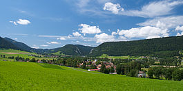
The municipality is located in a valley in the Neuchâtel Jura. The valley provides a connection between the Swiss plateau and Franche-Comte.
...
Wikipedia


