Uznach
| Uznach | ||
|---|---|---|
 |
||
|
||
| Coordinates: 47°14′N 8°59′E / 47.233°N 8.983°ECoordinates: 47°14′N 8°59′E / 47.233°N 8.983°E | ||
| Country | Switzerland | |
| Canton | St. Gallen | |
| District | See-Gaster | |
| Government | ||
| • Mayor | Erwin Camenisch | |
| Area | ||
| • Total | 7.55 km2 (2.92 sq mi) | |
| Elevation | 415 m (1,362 ft) | |
| Population (Dec 2015) | ||
| • Total | 6,295 | |
| • Density | 830/km2 (2,200/sq mi) | |
| Postal code | 8730 | |
| SFOS number | 3339 | |
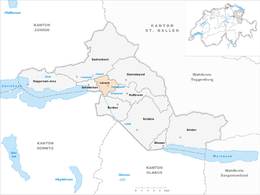
| Surrounded by | Benken, Ernetschwil, Eschenbach, Gommiswald, Kaltbrunn, Sankt Gallenkappel, Schmerikon, Tuggen (SZ) | |
| Website |
www SFSO statistics |
|
Uznach is a municipality in the Wahlkreis (constituency) of See-Gaster in the canton of St. Gallen in Switzerland.
Uznach is first mentioned in 741 as Uzinaa in a grant from a noble lady at Benken Abbey to the Abbey of Saint Gall. It was also mentioned later as both Uzinaha and Uzzinriuda.
In the late 12th Century, the village was transferred from the Abbey of St. Gallen to the Counts of Toggenburg. Between 1180 and 1195 Diethelm VI. married Guta of Rapperswil and received as dowry the county of Uznach and a rose from the crest of Rapperswil. From their castle in Uznach, the Toggenburgs raided trade caravans from Zurich until 1268 when the castle was conquered and destroyed by Rudolf von Habsburg.
Following the extinction of the Toggenburg line in 1436, the Old Zürich War broke out between the canton of Zürich and the other seven cantons of the Old Swiss Confederacy over the Toggenburg inheritance. The war lasted from 1436 until 1450 and ended with Zurich being brought back into the Confederation.
In 1529, a Reformation preacher was arrested in Uznach by Schwyz troops. This led to the outbreak of the First war of Kappel. Two years later the Second war of Kappel broke out and Uznach was again attacked by Zurich.
Uznach has an area, as of 2006[update], of 7.6 km2 (2.9 sq mi). Of this area, 47.1% is used for agricultural purposes, while 24.3% is forested. Of the rest of the land, 23.3% is settled (buildings or roads) and the remainder (5.3%) is non-productive (rivers or lakes).
...
Wikipedia


