Uri (canton)
| Kanton Uri | ||
|---|---|---|
| Canton of Switzerland | ||
|
||
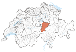
 Location in Switzerland |
||
| Coordinates: 46°47′N 8°37′E / 46.783°N 8.617°ECoordinates: 46°47′N 8°37′E / 46.783°N 8.617°E | ||
| Capital | Altdorf | |
| Subdivisions | 20 municipalities | |
| Government | ||
| • Executive | Regierungsrat (7) | |
| • Legislative | Landrat (64) | |
| Area | ||
| • Total | 1,076.57 km2 (415.67 sq mi) | |
| Population (12/2015) | ||
| • Total | 35,973 | |
| • Density | 33/km2 (87/sq mi) | |
| ISO 3166 code | CH-UR | |
| Highest point | 3,630 m (11,909 ft): | |
| Lowest point | 434 m (1,424 ft): Lake Lucerne | |
| Joined | 1291 | |
| Languages | German | |
| Website | UR.ch | |
The canton of Uri (German: Kanton ![]() Uri ) is one of the 26 cantons of Switzerland and a founding member of the Swiss Confederation. It is located in Central Switzerland. The canton's territory covers the valley of the Reuss between the St. Gotthard Pass and Lake Lucerne. The official language of Uri is (the Swiss variety of Standard) German, but the main spoken language is the Alemannic Swiss German dialect called Urner German. Uri was the only canton where the children in school had to learn Italian as their first foreign language. But in the school year of 2005/2006 this was changed to English as in most other cantons. The population is about 35,000 of which 3,046 (or 8.7%) are foreigners. The legendary William Tell is said to have hailed from Uri. The historical landmark Rütli lies within the canton of Uri.
Uri ) is one of the 26 cantons of Switzerland and a founding member of the Swiss Confederation. It is located in Central Switzerland. The canton's territory covers the valley of the Reuss between the St. Gotthard Pass and Lake Lucerne. The official language of Uri is (the Swiss variety of Standard) German, but the main spoken language is the Alemannic Swiss German dialect called Urner German. Uri was the only canton where the children in school had to learn Italian as their first foreign language. But in the school year of 2005/2006 this was changed to English as in most other cantons. The population is about 35,000 of which 3,046 (or 8.7%) are foreigners. The legendary William Tell is said to have hailed from Uri. The historical landmark Rütli lies within the canton of Uri.
The name of the valley is first mentioned in the 8th or 9th century, in the Latinized form of Uronia. In the medieval period, the name referred not to the entire Reuss valley but just to Altdorf and the surrounding settlements and estates. The extension of the name to a larger territory is the result of the territorial expansion of the canton in the 15th century. However, usage of Uri as referring to Altdorf remained current. From the 13th century onward, the German form of the name is recorded as Ure(n). The modern form Uri dates to the 16th century.
...
Wikipedia


