Upsall
| Upsall | |
|---|---|
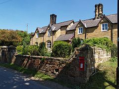
 Sandstone cottages in Upsall |
|
| Upsall shown within North Yorkshire | |
| Population | 60 |
| OS grid reference | SE453870 |
| District | |
| Shire county | |
| Region | |
| Country | England |
| Sovereign state | United Kingdom |
| Post town | THIRSK |
| Postcode district | YO7 2 |
| Dialling code | 01845 |
| Police | North Yorkshire |
| Fire | North Yorkshire |
| Ambulance | Yorkshire |
| EU Parliament | Yorkshire and the Humber |
| UK Parliament | |
Upsall is a hamlet in and civil parish in the Hambleton district of North Yorkshire, England. It is situated approximately four miles north-east of Thirsk. Upsall is part of the Upsall and Roxby estates owned by the Turton family. The population of the civil parish was estimated at 60 in 2014.
The village is mentioned in two entries of the Domesday Book as Upsale in the Yarlestre hundred. Lands at the time of the Norman invasion were in the possession of Earl Waltheof, but soon passed to the Crown from whence it was granted to Count Robert of Mortain. Some of the land was held for him by Richard of Soudeval. The lands passed to Robert de Mowbray, for whom the local Upsall family held the manor until 1327 when they were sold to Geoffrey Scrope. For a short while, the estates were Crown property before being granted to John Farnham in 1577. Thereafter, the lands passed through the Constable family to the Turtons in 1768.
The name Upsall is thought to derive from the Viking Upsal-ir, meaning high dwellings or high halls. The meaning is thus identical to one interpretation of Uppsala in Sweden.
The village lies within Thirsk and Malton UK Parliament constituency. It also lies within the Thirsk electoral division of North Yorkshire County Council and the Whitestonecliffe ward of Hambleton District Council.
The parish shares a grouped parish council, known as Hillside Parish Council, with the civil parishes of Boltby, Cowesby, Felixkirk and Kirby Knowle.
The nearest settlements are Knayton 1.24 miles (2 km) to the north west; Kirby Knowle 1.1 miles (1.8 km) to the east and Felixkirk 1.66 miles (2.67 km) to the south.
...
Wikipedia

