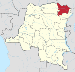
Upper Uele
| Haut-Uele Province | |
|---|---|
| Province | |
 |
|
| Coordinates: 2°46′35.02″N 27°37′4.48″E / 2.7763944°N 27.6179111°ECoordinates: 2°46′35.02″N 27°37′4.48″E / 2.7763944°N 27.6179111°E | |
| Country |
|
| Capital | Isiro |
| Largest city | Isiro |
| Government | |
| • Governor | Jean-Pierre Lola Kisanga |
| Area | |
| • Total | 89,683 km2 (34,627 sq mi) |
| Area rank | 14th |
| Population (2005 est.) | |
| • Total | 1,920,867 |
| • Rank | 17th |
| • Density | 21/km2 (55/sq mi) |
| Official language | French |
| National language | Lingala |
Haut-Uele (French for "Upper Uele") is one of the 26 provinces of the Democratic Republic of the Congo. Its capital is Isiro. The district takes its name, which means "upper Uele" in French, from the Uele River.
Prior to 2015, Haut-Uele was administered as a district as part of Orientale Province.
The principal communities are Niangara, Dungu, Faradje, Watsa, Rungu, Isiro and Wamba. The capital of the district is the town of Isiro.
Territories are
...
Wikipedia
