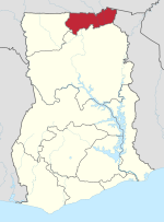
Upper East Region
| Upper East Region, Dagbon | |
|---|---|
| Region | |
 Location of Upper East Region in Ghana |
|
 Districts of Upper East region, |
|
| Country | Ghana |
| Capital | Bolgatanga |
| Districts | 10 |
| Government | |
| • Regional Minister | Ephraim Avea Nsoh |
| Area | |
| • Total | 8,842 km2 (3,414 sq mi) |
| Area rank | Ranked 9th |
| Population (2010 Census) | |
| • Total | 1,046,545 |
| • Rank | Ranked 9th |
| • Density | 120/km2 (310/sq mi) |
| GDP (PPP) | |
| • Year | 2013 |
| • Per capita | $5,150 |
| GDP (Nominal) | |
| • Year | 2013 |
| • Per capita | $2,500 |
| Time zone | GMT |
| Area code(s) | 039 |
| ISO 3166 code | GH-UE |
The Upper East Region is located in north Ghana and is the second smallest of 10 administrative regions in Ghana, occupying a total land surface of 8,842 square kilometers or 2.7 per cent of the total land area of Ghana. The Upper East regional capital is Bolgatanga, sometimes referred to as Bolga. Other major towns in the region include Navrongo, Paga, Bawku and Zebilla.
The Upper East region is located in the north-eastern corner of Ghana, precisely located in the Kingdom of Dagbon, and bordered by Burkina Faso to the north and Togo to the east. It lies between longitude 0° and 1° West, and latitudes 10° 30′N and 11°N. The region shares boundaries with Burkina Faso to the north, Togo to the east, Upper West Region to the west, and the Northern Region to the south. The Upper East region is divided into 10 districts, each headed by a district chief executive.
The region plays host to many festivals throughout the year, most of which are either to bring a good planting season or celebrate the harvest.
The center of population of the Upper East Region is located in its capital of Bolgatanga.
The population is primarily rural (79%) and scattered in dispersed settlements. The rural population was 87.1 percent in 1984 and 84.3% in 2000. There was, thus, a 2.8 percentage point reduction in the rural share of the population between 1984 and 2000 and a further 5.3 percent reduction between 2000 and 2010.
With only 21 per cent of the population living in urban areas, the region is the least urbanized in Ghana. In fact, together with Upper West, they are the two regions with a less than 20 per cent urban population.
Ghanaian citizen by birth, childhood or parenthood constitute 92.5 percent of the population of the Upper East region. Naturalized Ghanaian citizen constitute 5.3 percent.
Three national highways – N2, N10, and N11 – and a few Regional highways such as the R113, R114, R116 and R181, serve the region.
...
Wikipedia
