Upper Augusta Township, Pennsylvania
| Upper Augusta Township, Pennsylvania | |
|---|---|
| Township | |

Scenery in Upper Augusta Township
|
|
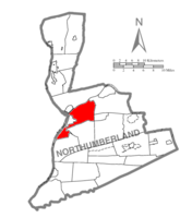
 Map of Northumberland County, Pennsylvania highlighting Upper Augusta Township |
|
 Map of Northumberland County, Pennsylvania |
|
| Country | United States |
| State | Pennsylvania |
| County | Northumberland |
| Settled | 1701 |
| Incorporated | 1846 |
| Government | |
| • Type | Board of Supervisors |
| Area | |
| • Total | 23.3 sq mi (60.3 km2) |
| • Land | 20.3 sq mi (52.8 km2) |
| • Water | 3.0 sq mi (7.5 km2) |
| Population (2010) | |
| • Total | 2,586 |
| • Density | 127.4/sq mi (49.0/km2) |
| Time zone | Eastern (EST) (UTC-5) |
| • Summer (DST) | EDT (UTC-4) |
| Area code(s) | 570 |
Upper Augusta Township is a township in Northumberland County, Pennsylvania, United States. It was formed in 1846 by the division of Augusta Township (one of the seven original townships of Northumberland County formed in 1772) into Upper and Lower sections. The population at the 2010 Census was 2,586, up from 2,556 at the 2000 census.
The Keefer Station Covered Bridge and Sunbury Armory are listed on the National Register of Historic Places.
Voters rejected a tax referendum in May 2007 which would have increased local earned income tax by 0.5 percent to reduce property taxes for homeowners and farmers by $176.
According to the United States Census Bureau, the township has a total area of 23.3 square miles (60.3 km²), of which, 20.3 square miles (52.5 km²) of it is land and 3.0 square miles (7.8 km²) of it (12.97%) is water.
As of the census of 2000, there were 2,556 people, 1,022 households, and 781 families residing in the township. The population density was 126.2 people per square mile (48.7/km²). There were 1,058 housing units at an average density of 52.2/sq mi (20.2/km²). The racial makeup of the township was 98.16% White, 0.51% African American, 0.08% Asian, 0.12% Pacific Islander, 0.47% from other races, and 0.67% from two or more races. Hispanic or Latino of any race were 0.74% of the population.
...
Wikipedia
