University District, Seattle, Washington
| University District | |
|---|---|
| Seattle Neighborhood | |

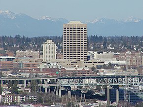
The U-District, looking northeast from Queen Anne. UW Tower is the tall building in the center, with the Hotel Deca (originally the Meany Hotel) to its left. The I-5 Ship Canal Bridge is in the foreground.
|
|
 Map of the University District's location in Seattle |
The University District (commonly, the U District) is a district of neighborhoods in Seattle, Washington, so named because the main campus of the University of Washington (UW) is located there. The UW moved in two years after the area was annexed to Seattle, while much of the area was still clear cut forest or stump farmland. The district of neighborhoods grew with the university to become like a smaller version of urban American cities.
Neighborhoods within the district include University Park (east from 15th to 25th Avenues N.E., north from N.E. 50th Street to N.E. Ravenna Boulevard), Greek Row (N.E. 45th to N.E. 50th Streets, 15th to 25th Avenues N.E.), University Heights (north of N.E. 45th Street and west of 15th Avenue N.E.) and the Brooklyn Addition (residential and Bohemian area west of 15th Avenue N.E. and south of N.E. 45th Street); as well as the Main, West and North campuses of the University of Washington.
Like all Seattle districts, the boundaries of the University District are informal; by common usage, the University District is bounded on the west by Interstate 5; on the east by 25th Avenue NE; on the south by the Lake Washington Ship Canal; and on the north by NE Ravenna Boulevard. It also includes, east of these boundaries, a small district on the north shore of Union Bay, bounded on the north by NE 45th Street and on the east by 35th Avenue NE. This extension consists mainly of the "east campus" and extensive parking lots of the University. Its main commercial street, University Way NE, is known throughout the city as "The Ave" in the "U District".
Some parts of the University District have had names of their own. For example, today "University Heights" mainly designates a former school used as a community center, University Heights Center for the Community; a 1905 map shows the name as applying specifically to the area bounded by what are now NE 45th Street to the south, NE 55th Street to the north, Brooklyn Avenue NE to the west, and 15th Avenue NE to the east.
What is now the University District has been inhabited since the end of the last glacial period (c. 8,000 BCE—10,000 years ago). Prominent Native American Duwamish villages of the Lushootseed (Skagit-Nisqually) Coast Salish nations were on a then-larger Portage Bay at what is now called Brooklyn Avenue, and the other on a larger Union Bay, near the present UW power plant (which is across from the UW IMA building), around the north shores a mile farther than today, and shores east of what is now the Union Bay Natural Area. (See also adjacent Ravenna neighborhood.) The Duwamish, ("People of the Inside") tribe had the prominent village of SWAH-tsoo-gweel ("portage") on then-adjacent Union Bay, and what is now Ravenna was their backyard before the arrival of European settlers. Villages were diffuse. In spring, people dispersed from their winter villages of longhouses to camps, gathering in summer for salmon. Gaps in the forest were maintained to encourage game and food supplies. Such "prairies" (anthrogenic grasslands) were cultivated in what is now the University District. They were connected by a well-travelled path along what is now the Lake Washington Ship Canal (1883, 1916).
...
Wikipedia
