Unguja

Unguja
|
|
| Location in Tanzania | |
| Geography | |
|---|---|
| Coordinates | 6°08′S 39°20′E / 6.133°S 39.333°ECoordinates: 6°08′S 39°20′E / 6.133°S 39.333°E |
| Archipelago | Zanzibar Archipelago |
| Area | 1,666 km2 (643 sq mi) |
| Length | 85 km (52.8 mi) |
| Width | 30 km (19 mi) |
| Highest elevation | 195 m (640 ft) |
| Highest point | Unnamed point in the Koani chain |
| Administration | |
| Region | Zanzibar |
| Demographics | |
| Population | 896,721 (2012) |
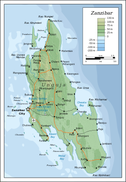
Unguja (also referred to as Zanzibar Island or simply Zanzibar, in Ancient Greek Menuthias, Μενουθιάς - as mentioned in The Periplus of the Erythraean Sea, in Greek: Περίπλους τὴς Ἐρυθράς Θαλάσσης -) is the largest and most populated island of the Zanzibar archipelago, in Tanzania.
Unguja is a hilly island, about 85 kilometres (53 miles) long (north-south) and 30 kilometres (19 miles) wide (east-west) at its widest, with an overall area of about 1,666 square kilometres (643 square miles). It is located in the southern half of the Zanzibar Archipelago, in the Indian Ocean, about 59 kilometres (37 mi) south of the second largest island of the archipelago, Pemba. Unguja and mainland Tanzania are separated by the Zanzibar Channel.
Unguja is surrounded by a number of smaller islands and islets, with only two of them, Tumbatu and Uzi, being inhabited. Other minor islands around Unguja include Bawe, Chapwani, Changuu, Chumbe, Kizingo, Kwale, Latham, Mautani, Miwi, Mnemba, Mwana wa Mwana, Nianembe, Popo, Pungume, and Ukanga.
Unguja and the surrounding islands are divided in three regions: Zanzibar Central/South (capital: Koani), Zanzibar North (capital: Mkokotoni), Zanzibar Urban/West (capital: Zanzibar City). Unguja belongs to Zanzibar, which is defined by the Tanzanian Constitution as "a part" of Tanzania with a high degree of autonomy. The local Zanzibari government is based in Stone Town, on the west coast of Unguja.
...
Wikipedia

