Unalaska Bay
| Unalaska Bay | |
|---|---|

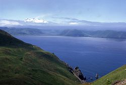
Broad Bay and the Makushin Volcano partly hidden by low clouds and the Makushin valley.
|
|
| Coordinates | 53°56′55″N 166°29′54″W / 53.94861°N 166.49833°WCoordinates: 53°56′55″N 166°29′54″W / 53.94861°N 166.49833°W |
| Type | Bay |
| Ocean/sea sources | Pacific Ocean |
| Basin countries | United States |
| Max. length | n/a |
| Max. width | n/a |
| Surface area | n/a |
| Settlements |
Dutch Harbor Unalaska |
Unalaska Bay is a waterway of Unalaska Island in the U.S. state of Alaska. It is situated below the eastern slopes of Makushin Volcano. Composed of seven individual bays, Unalaska Bay opens onto the Bering Sea.
Unalaska Bay is the general name of the indentation making in to the north end of Unalaska Island between Cape Kalekhta and Cape Cheerful. Commercially, it was the most important bay in western Alaska in the beginning of the 20th century. Its shores are generally mountainous with precipitous sea faces. Amaknak Island lies in its southern end. Westward of the island the water is deep, but there is no good harbor in this part of the bay; eastward of the island are the important anchorages of Dutch Harbor, Iliuliuk Bay, and Iliuliuk Harbor. The channel to Iliuliuk Bay and Dutch Harbor is free from dangers except along the shores. Iliuliuk Harbor is obstructed at its entrance by ledges.
Cape Cheerful, the western point at the entrance to Unalaska Bay, is made up of bold, very high headlands, rounded on top, and intersected by deep, grassy valleys. The shore is free from dangers and has deep water close-to. A cascade, 125 feet high, south of Cape Cheerful, is a conspicuous mark from the vicinity of Cape Kalekhta, and is useful in thick weather when only the lower part of the land can be seen.
Ulakhta Head, 900 feet high, the north end of Amaknak Island, is, in clear weather, one of the best landmarks for fixing the position of Unalaska Bay. In appearance it is like a pyramid with the top cut off. The top shows perfectly flat, and there is no other headland or mountain in this vicinity that has this feature. It is not as high as the background, but shows up well against it, and can be made out at a long distance from the bay. From its northwest point a reef extends off | mile, marked by Needle Rock, similar in appearance to Priest Rock, but not so large. From its northeast point a long, narrow sand spit extends to the southward l£ miles; its southern end, called Spithead, is marked by a beacon, about 15 feet high, standing close to its southern shore.
Princess Head, 2 miles from Cape Kalekhta, is a large square-headed rock that projects from the shore far enough to be distinctly observed, even in thick weather, in following along the east shore.
...
Wikipedia
