Uijongbu
|
Uijeongbu 의정부시 |
||
|---|---|---|
| Municipal City | ||
| Korean transcription(s) | ||
| • Hangul | ||
| • Hanja | ||
| • Revised Romanization | Uijeongbu-si | |
| • McCune-Reischauer | Ŭijŏngbu-shi | |
 |
||
|
||
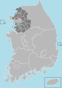
 Location in South Korea |
||
| Country |
|
|
| Region | Gyeonggi-do | |
| Administrative divisions | 15 dong | |
| Area | ||
| • Total | 81.59 km2 (31.50 sq mi) | |
| Population (August 2016) | ||
| • Total | 436,527 | |
| • Density | 5,350.3/km2 (13,857/sq mi) | |
| • Dialect | Seoul | |
Coordinates: 37°44′35″N 127°02′04″E / 37.743164°N 127.03448°E
Uijeongbu (Korean pronunciation: [ɰi.dʑʌŋ.bu]) is a city in Gyeonggi Province, South Korea.
Uijeongbu is located north of the Korean capital Seoul; it lies inside a defile, with mountains on two sides, and commands a natural choke point across the main traditional invasion route from the North into Seoul. As such it has a continued military significance and it contains U.S. and Korean military bases, positioned for the defense of the Korean capital. The U.S. Second Infantry Division has established a headquarters post in Uijeongbu, with the main troops being deployed from Dongducheon city.
Despite being known for its military presence, the area has boomed into a satellite community of Seoul with shops, cinemas, restaurants and bars, PC bangs and DVD Bangs. In addition to U.S. personnel, it is popular with the English hagwon (a for-profit private institute, academy or cram school). There are several mountains such as Mt. Dobong (Dobongsan), Mt. Surak and Mt. Soyo. The mountains are popular recreational areas for hiking and are frequented by residents living in the Seoul Metropolitan area.
...
Wikipedia

