U.S. Route 45 in Alabama
| U.S. Route 45 | ||||
|---|---|---|---|---|

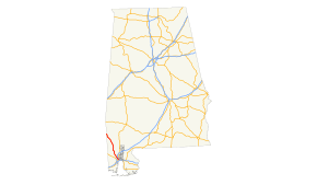
Map of southern Alabama with US 45 highlighted in red
|
||||
| Route information | ||||
| Maintained by ALDOT | ||||
| Length: | 60 mi (97 km) | |||
| Major junctions | ||||
| South end: |
|
|||
| North end: |
|
|||
| Location | ||||
| Counties: | Mobile, Washington | |||
| Highway system | ||||
|
||||
In the U.S. state of Alabama, U.S. Route 45 (US 45) is a 60-mile-long (97 km) north–south United States Highway in the east south central state of Alabama. It travels from Mobile to the Mississippi state line, just east of State Line, Mississippi. The highway's southern terminus is in Mobile, at an intersection with US 98. Its northern terminus in the state of Alabama is at the Mississippi state line, where the highway continues to the northwest into that state.
In Alabama, all of the U.S. Highways have one or more unsigned state highways designated along its length. US 45 travels concurrently with State Route 17 (SR 17) from its southern terminus to just north of Deer Park. For the rest of its length in the state, the highway travels concurrently with SR 57.
US 45, along with unsigned SR 17, begins at an intersection with US 98 (Spring Hill Avenue; unsigned SR 42) in the central part of Mobile, in Mobile County. US 45 heads to the northwest and travels just north of Lyons Park and skirts along the northeastern edge of USA Children's & Women's Hospital. It crosses over Threemile Creek and curves to the north-northwest. It passes just to the east of Washington Middle School and Carver Park. Just after passing Gorgas Park and LeFlore Magnet High School, the highway curves back to the northwest. At an intersection with West Prichard Avenue, it leaves Mobile and enters Prichard. It crosses over some railroad tracks of Canadian National Railway just before an interchange with Interstate 65 (I-65). The highway passes Whispering Pines Cemetery just before crossing over Eightmile Creek. Almost immediately, it intersects the southern terminus of SR 213 (South Shelton Beach Road). Approximately 1,000 feet (300 m) later is an intersection with the southern terminus of SR 217 (Lott Road). US 45 passes John F. Fagerstrom Municipal Park and then Collins–Rhodes Elementary School. It curves to the north-northeast and crosses over Seabury Creek. The highway curves to a nearly due north direction and has an interchange with SR 158 (Industrial Parkway). It curves back to the northwest and travels through Kushla, which is within the city limits of Prichard. Immediately after leaving the city, the highway crosses over Magee Creek. It then enters Mauvilla. Here, it intersects the southern terminus of County Route 78 (CR 78; Spice Pond Road). Just northeast of Mauvilla Cemetery is an intersection with the southern terminus of CR 55 (Kali Oka Road). US 45 curves to the north-northwest, leaves Mauvilla, and crosses over Williams Creek. It curves to the north and crosses over Silver Creek. It curves to the north-northeast and enters Chunchula. The highway curves back to the north-northwest and enters the main part of the community. There, the highway has an intersection with CR 63 (Chunchula–Georgetown Road/Roberts Road). It curves back to the northwest and crosses over Beaver Pond Creek. It curves back to the north-northwest and crosses over Sweetwater and Drinking branches. It heads to the north-northeast and crosses over Sand Hill Creek. In Gulfcrest, the highway intersects the eastern terminus of CR 92 (Gulfcrest Road). The highway curves to the north and passes McDavid–Jones Elementary School. Then, it enters Citronelle. Almost immediately is an intersection with CR 41 (Celeste Road), which begins to parallel the U.S. Highway. It passes Lott Middle School and then Pilgrims Rest Cemetery. At an intersection with the southern terminus of Main Street, CR 41 ends its paralleling of US 45. It curves to the north and crosses over Puppy Creek. In the main part of Citronelle, it has an intersection with both CR 96 (West State Street) and the northern terminus of CR 41 (East State Street). CR 96 has a brief unsigned concurrency with US 45. On the northeastern edge of the intersection is War Memorial Park. One block later, CR 96 splits off to the east, onto Lebaron Avenue. On the northeastern edge of the intersection, US 45 passes the new campus of Citronelle High School. It curves to the north-northwest and briefly leaves Citronelle. It passes Wesleyan Christian Academy and then re-enters the city for a very short stint. During the last stint, it crosses over Bennett Creek. Upon leaving the city, it enters Washington County.
...
Wikipedia

