U.S. Route 425 in Arkansas
| U.S. Route 425 | |
|---|---|
 |
|
| Route information | |
| Length: | 220 mi (354 km) |
| Existed: | 1989 (extended north in 2002, south in 2005) – present |
| Major junctions | |
| South end: |
|
|
|
|
| North end: |
|
| Location | |
| States: | Mississippi, Louisiana, Arkansas |
| Highway system | |
| Louisiana Highway 137 | |
|---|---|
| Location: | Morehouse and Richland Parishes |
| Length: | 18.08 mi (29.10 km) |
| Existed: | 1955–2005 |
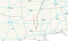
U.S. Route 425 (US 425) is a north–south United States highway, first commissioned in 1989. Its route number is a "violation" of the usual AASHTO numbering scheme, as it comes nowhere near its implied "parent", US 25.
Another anomaly is US 425's absorption of US 65, forming US 65's southern terminus. The route's northern terminus is in Pine Bluff, Arkansas, at an interchange with Interstate 530/U.S. Route 63/U.S. Route 65/U.S. Route 79/US 65B/AR 190. Until 2005, its southern terminus was in Bastrop, Louisiana, at an intersection with U.S. Route 165. In 2005, it was extended to Natchez, Mississippi, at an intersection with U.S. Route 61.
US 425 is a piecing together of former state highways. Most of US 425 in Louisiana, for example, is merely a concurrency with LA 15.
From its southern terminus in Natchez, Mississippi, US 425 crosses the Mississippi River and runs concurrent with US 84 for approximately 14 miles to Ferriday, Louisiana. It then splits and heads northeast, running concurrently with LA 15 through mostly farmland and small towns. Just north of Clayton is the southern terminus of US 65. Passing through Winnsboro the highways split at Archibald. LA 15 continues northeast to Monroe, LA while US 425 heads north to Rayville where it crosses I-20. At Mer Rouge, it intersects US 165 and the two highways run concurrent to Bastrop, LA. A few miles north of Bastrop, US 425 crosses into Arkansas south of Crossett.
...
Wikipedia

