U.S. Route 16A (South Dakota)
| U.S. Highway 16A | ||||
|---|---|---|---|---|
 |
||||
| Route information | ||||
| Auxiliary route of US 16 | ||||
| Defined by SDCL §31-4-139 | ||||
| Maintained by SDDOT | ||||
| Length | 36.971 mi (59.499 km) | |||
| Major junctions | ||||
| West end |
|
|||
| East end |
|
|||
| Location | ||||
| Counties | Custer, Pennington | |||
| Highway system | ||||
|
||||
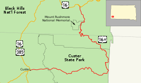
U.S. Route 16A (US 16A) is a 36.971-mile-long (59.499 km) scenic United States highway. It is an alternate route for US 16. It splits from US 16 in the Black Hills of the southwestern part of the U.S. state of South Dakota. The highway's western terminus is an intersection with US 16, US 385, and South Dakota Highway 89 (SD 89) in Custer, South Dakota. The eastern terminus is at an interchange with US 16 called the Keystone Wye south of Rapid City, South Dakota.
The route passes through Keystone, South Dakota; Norbeck Wildlife Refuge; Mount Rushmore National Memorial; and Custer State Park (including State Game Lodge and Legion Lake); before rejoining the parent highway.
US 16A is famous for its scenic, one-lane tunnels aligned to frame the faces on Mount Rushmore, its "pigtail bridges", and its sections of divided highway but with single (and narrow) lanes on each roadway. It is the only route which can be used to drive through Custer State Park without having to pay an entrance fee for the park, provided the traveler does not stop in the Park.
...
Wikipedia

