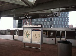
Tysons Corner station
| Washington Metro rapid transit station | |||||||||||

Tysons Corner station on opening day - July 26, 2014
|
|||||||||||
| Location | 1943 Chain Bridge Road Mclean, Virginia 22102 |
||||||||||
| Coordinates | 38°55′14″N 77°13′19″W / 38.92063°N 77.22193°W | ||||||||||
| Owned by | WMATA | ||||||||||
| Line(s) | |||||||||||
| Platforms | 1 island platform | ||||||||||
| Tracks | 2 | ||||||||||
| Connections |
|
||||||||||
| Construction | |||||||||||
| Structure type | Elevated | ||||||||||
| Other information | |||||||||||
| Station code | N02 | ||||||||||
| History | |||||||||||
| Opened | July 26, 2014 | ||||||||||
| Traffic | |||||||||||
| Passengers (2016) | 2,970 daily |
||||||||||
| Services | |||||||||||
|
|||||||||||
Tysons Corner (also known as Tysons Central 123 and Tysons I & II during planning phases) is a rapid transit station on the Silver Line of the Washington Metro in Tysons Corner, Virginia. One of four Metro stations in Tysons Corner, it is one of the five stations comprising the first phase of the Silver Line, which opened on July 26, 2014.
Like other stations on the Silver Line, Tysons Corner has an elevated island platform and two tracks. Access is provided by two entrances, one at street level at the northwest corner of the intersection of Chain Bridge Road and Tysons Boulevard and the other on the southwest corner; the siting of the railway viaduct on the north side of Chain Bridge Road as well as pedestrian safety means that entrance to the station from this corner is by a pedestrian overpass to a mezzanine above platform level.
Tysons Corner station opened as part of the first phase of the Silver Line to Wiehle – Reston East in 2014. In the planning stages, controversy ensued over whether to build the Metro in a tunnel or on an elevated viaduct through Tysons Corner. It was eventually decided that the majority of the line would be built above ground, but the station was built partially below ground in order to send trains through a short tunnel connecting the line's Route 7 and Route 123-paralleling sections.
One of four Metro stations within Tysons Corner, the eponymous station is located in the heart of the edge city. Specifically, it lies above Chain Bridge Road (VA 123) at its intersection with Tysons Boulevard. It is the closest station to two of the region's most important attractions, Tysons Corner Center and Tysons Galleria, which combined house roughly 3.0 million square feet, or half of the region's retail space.
In order to reduce congestion and improve walkability and connectivity in the area, the Fairfax County Planning Commission created the "Tysons Corner Urban Center Comprehensive Plan", an outline for the urbanization of Tysons Corner in conjunction with the opening of the Silver Line. As one of four Metro stations within the identified locale, the station is the focal point of one of the transit-oriented development schemes in the plan. According to the Commission's outline, the area bounded by Westpark Drive, International Drive, Route 123, Route 7 and the Capital Beltway will be designated as the Tysons Central 7 District and contain high-density residential and commercial mixed-use development.
...
Wikipedia
