Tyne Bridge (UK Parliament constituency)
| Tyne Bridge | |
|---|---|
| Former Borough constituency for the House of Commons |
|

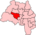
Boundary of Tyne Bridge in Tyne and Wear for the 2005 general election.
|
|

Location of Tyne and Wear within England.
|
|
| County | Tyne and Wear |
| 1983–2010 | |
| Number of members | One |
| Replaced by | Gateshead, Newcastle upon Tyne Central |
| Created from | Gateshead West, Newcastle upon Tyne Central, Newcastle upon Tyne West, Blaydon, Newcastle upon Tyne North and Gateshead East |
Coordinates: 54°58′05″N 1°36′22″W / 54.968°N 1.606°W
Tyne Bridge was a parliamentary constituency in the north east of England, represented in the House of Commons of the Parliament of the United Kingdom, from 1983 until 2010. It elected one Member of Parliament (MP) by the first past the post system of election.
Tyne Bridge contained some of the UK's most deprived areas, and was a safe seat for the Labour Party throughout its existence.
1983-1997: The City of Newcastle wards of Benwell, Elswick, Scotswood, and West City, and the Metropolitan Borough of Gateshead wards of Bede, Bensham, Dunston, and Teams.
1997-2010: The City of Newcastle wards of Benwell, Elswick, Scotswood, and West City, and the Metropolitan Borough of Gateshead wards of Bede, Bensham, Deckham, Dunston, Saltwell, and Teams.
The constituency covered central Tyneside in Tyne and Wear, with part of the constituency being north of the River Tyne in Newcastle, and the other part being south of the river, in Gateshead. It is named for the Tyne Bridge that crosses the river. It included Newcastle city centre; before 1983, this area was in the Newcastle-upon-Tyne North seat.
...
Wikipedia
