Twyfelfontein
| Twyfelfontein (Afrikaans) ǀUi-ǁAis (Khoekhoegowab) |
|
|---|---|
| Name as inscribed on the World Heritage List | |
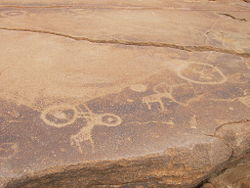
 A sandstone slab at Twyfelfontein. The animals are the older engravings, overlaid by the circles. |
|
| Location | Namibia |
| Type | Cultural |
| Criteria | iii, v |
| Reference | 1255 |
| UNESCO region | Africa |
| Inscription history | |
| Inscription | 2007 (31st Session) |
| Twyfelfontein | |
|---|---|
| Location in Namibia | |
| Coordinates: 20°35′26″S 14°22′20″E / 20.59056°S 14.37222°E | |
| Country |
|
| Region | Kunene Region |
| Constituency | Khorixas Constituency |
| Area | |
| • Land | 0.222 sq mi (0.574 km2) |
| • Water | 0 sq mi (0 km2) |
| Elevation | 1,800 ft (550 m) |
| Time zone | South African Standard Time (UTC+1) |
Twyfelfontein (Afrikaans: uncertain spring), officially known as ǀUi-ǁAis (Damara/Nama: jumping waterhole), is a site of ancient rock engravings in the Kunene Region of north-western Namibia. It consists of a spring in a valley flanked by the slopes of a sandstone table mountain that receives very little rainfall and has a wide range of diurnal temperatures.
The site has been inhabited for 6,000 years, first by hunter-gatherers and later by Khoikhoi herders. Both ethnic groups used it as a place of worship and a site to conduct shamanist rituals. In the process of these rituals at least 2,500 items of rock carvings have been created, as well as a few rock paintings. Displaying one of the largest concentrations of rock petroglyphs in Africa, UNESCO approved Twyfelfontein as Namibia's first World Heritage Site in 2007.
Twyfelfontein valley has been inhabited by Stone-age hunter-gatherers of the Wilton stone age culture group since approximately 6,000 years ago. They made most of the engravings and probably all the paintings. 2,000 to 2,500 years ago the Khoikhoi, an ethnic group related to the San (Bushmen), occupied the valley, then known under its Damara/Nama name ǀUi-ǁAis (jumping waterhole). The Khoikhoi also produced rock art which can clearly be distinguished from the older engravings.
The area was uninhabited by Europeans until after World War II, when a severe drought caused white Afrikaans speaking farmers (Boers) to move in. The farm was later procured by the apartheid government as part of the Odendaal Plan and became part of the Damaraland bantustan. The white settlers left in 1965.
...
Wikipedia

