Tutshill
| Tutshill | |
|---|---|
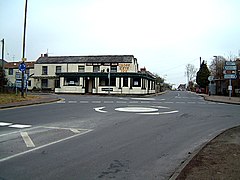
 Crossroads at Tutshill |
|
| Tutshill shown within Gloucestershire | |
| OS grid reference | ST539946 |
| District | |
| Shire county | |
| Region | |
| Country | England |
| Sovereign state | United Kingdom |
| Post town | CHEPSTOW |
| Postcode district | NP16 |
| Dialling code | 01291 |
| Police | Gloucestershire |
| Fire | Gloucestershire |
| Ambulance | South Western |
| EU Parliament | South West England |
Tutshill is a small village within the parish of Tidenham in the Forest of Dean, Gloucestershire, England. It is located on the eastern bank of the River Wye, which forms the boundary with Monmouthshire at this point and which separates the village from the town of Chepstow. The village of Woodcroft adjoins Tutshill to the north, and across the A48 road to the south is the village of Sedbury. A short walk over the river is Chepstow railway station on the Gloucester to Newport Line.
The name derives from the ruined "tut", a local term for watchtower, on top of the hill overlooking the River Wye and its ancient crossing point at Castleford. and also having a distant view of the River Severn and estuary. The tower is of uncertain date, and has been suggested as either an Anglo-Norman watchtower linked to Chepstow Castle, or a later windmill. A windmill overlooking the Wye above Chapelhouse Wood is recorded in 1584. It may have been later adapted as a folly, leading to a local tradition that the ruined mill had been a look-out tower.
Tutshill was once common land in "Bishton tithing" to the south of Tidenham Chase. The only house near the crossroads at Tutshill before the 19th century was apparently Tutshill Farm recorded from 1655.
After the town of Chepstow developed and a bridge was built over the Wye, the main road between Gloucestershire and Monmouthshire followed the steep hill directly up the river bank between the bridge and Tutshill – now a footpath linking Chepstow to the Offa's Dyke Path – until a new road looping around Castleford Hill was opened in 1808. This road carried traffic between the two counties until a new bridge was built at Chepstow in 1988, whereupon Tutshill was bypassed.
...
Wikipedia

