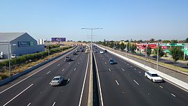
Tullamarine Freeway
|
Tullamarine Freeway Victoria |
|
|---|---|
 |
|
| Tullamarine Freeway at Airport West | |
| Type | Freeway |
| Length | 13 km (8.1 mi) |
| Opened | 1965-1979 |
| Route number(s) |
|
| Former route number |
|
| Northwest end |
|
|
|
| Southeast end |
|
| Major suburbs / towns | Gladstone Park, Essendon, Pascoe Vale |
|
Highways in Australia National Highway • Freeways in Australia Highways in Victoria |
|
The Tullamarine Freeway is a major urban freeway in Melbourne, linking Melbourne Airport to the central business district. It carries up to 200,000 vehicles per day and is one of Australia's busiest freeways. The entire stretch of the Tullamarine Freeway bears the designation State Route 43 duplexed with M2. The freeway was originally shown in the 1969 Melbourne Transportation Plan as part of the F14 Freeway corridor.
The Tullamarine Freeway is one of the oldest freeways in Melbourne. The first stage of construction was completed in the financial year 1965/66 between Mickleham Road and "the Tullamarine Jetport Terminal area" (Melbourne Airport), with the initial 7.2-kilometre (4.5 mi) section between Melbourne Airport and Lancefield Road at Essendon Airport officially opening early 1968. This section was originally referred to as the "Tullamarine By-pass Road". From Essendon, a new section heading east to Pascoe Vale and then south along the Moonee Ponds Creek to Mt Alexander Road, Flemington was opened to traffic in 1970. This new section replaced Mount Alexander Road as the main route to the city. In 1979, the section of Lancefield Road running along the western edge of Essendon Airport was upgraded to freeway standard, completing the freeway.
The freeway was initially designated F81 for the whole stretch from Tullamarine to Flemington. The freeway was originally designated in the 1969 Melbourne Transportation Plan as the F14 Freeway corridor.
With its completion, city-bound heavy vehicles from Hume Highway were diverted here via Pascoe Vale Road. In the 1990s, the completion of the Western Ring Road increased traffic tremendously. It was only relieved by the completion of CityLink, widening the freeway to 8 lanes (two of these being transit lanes) and extending it south to the West Gate Freeway. The improved sections are now tolled.
...
Wikipedia
