Tullahassee, Oklahoma
| Tullahassee, Oklahoma | |
|---|---|
| Town | |
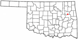
 Location of Tullahassee, Oklahoma |
|
| Coordinates: 35°50′16″N 95°26′21″W / 35.83778°N 95.43917°WCoordinates: 35°50′16″N 95°26′21″W / 35.83778°N 95.43917°W | |
| Country | United States |
| State | Oklahoma |
| County | Wagoner |
| Area | |
| • Total | 0.5 sq mi (1.4 km2) |
| • Land | 0.5 sq mi (1.4 km2) |
| • Water | 0.0 sq mi (0.0 km2) |
| Elevation | 620 ft (189 m) |
| Population (2000) | |
| • Total | 106 |
| • Density | 200.4/sq mi (77.4/km2) |
| Time zone | Central (CST) (UTC-6) |
| • Summer (DST) | CDT (UTC-5) |
| ZIP code | 74454 |
| Area code(s) | 539/918 |
| FIPS code | 40-74650 |
| GNIS feature ID | 1099007 |
Tullahassee is a town in Wagoner County, Oklahoma, United States. The population was 106 in both the 2010 and the 2000 census. It was also the location of Tullahassee Mission. It is considered the oldest of the all-Black towns in Oklahoma.
The town began in 1850, when the Creek Nation constructed a school at this site on the Texas Road. By 1881, the population of freedmen had increased in the area, while the number of Native Americans had declined. The Creek Council then transferred the Creek children to another school and gave the town of Tullahassee to the freedmen. A post office opened in 1899, and the town was incorporated in 1902. It is now the oldest of the 13 remaining all-Black towns in the state.
In 1916, the African Methodist Episcopal Church (AME) opened Flipper Davis College in the old Tullahassee Mission building. The college was the only private higher level education institution for African Americans in Oklahoma. This school closed in 1935.
Tullahassee is located at 35°50′16″N 95°26′21″W / 35.83778°N 95.43917°W (35.837758, -95.439295). It is 5 miles (8.0 km) northwest of Muskogee, Oklahoma.
According to the United States Census Bureau, the town has a total area of 0.5 square miles (1.3 km2), all of it land.
As of the census of 2000, there were 106 people, 39 households, and 24 families residing in the town. The population density was 200.4 people per square mile (77.2/km²). There were 49 housing units at an average density of 92.6 per square mile (35.7/km²). The racial makeup of the town was 66.98% African American, 28.30% White, 0.94% Native American, and 3.77% from two or more races.
...
Wikipedia
