Tsimanampetsotsa National Park
| Tsimanampetsotsa National Park | |
|---|---|
|
IUCN category II (national park)
|
|

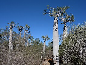
Pachypodium geayi in Tsimanampetsotsa
|
|
|
Map of Madagascar
|
|
| Location | South-west Madagascar |
| Nearest city | Toliara |
| Coordinates | 24°05′56″S 43°49′55″E / 24.099°S 43.832°ECoordinates: 24°05′56″S 43°49′55″E / 24.099°S 43.832°E |
| Area | 456 km2 (176 sq mi) |
| Established | 1927 |
Tsimanampetsotsa National Park also spelt Tsimanampetsotse, and known as Tsimanampetsotsa Nature Reserve is a national park in the region Atsimo-Andrefana in Madagascar. It lies on the south-west coast and contains Lake Tsimanampetsotsa, an important wetland which is registered as a Ramsar Wetland of International Importance .
Tsimanampetsotsa was first protected in 1927 for its endemic flora and fauna and became a national park in 1966.
The park is 90 kilometres (56 mi) south of Toliara and 950 kilometres (590 mi) south of the capital, Antananarivo. Route Nationales (RN) 10 to Faux Cap passes the park and the nearest airport is at Toliara. The climate is hot and dry with drought for nine to eleven months of the year, and the annual rainfall is less than 300 millimetres (12 in), which makes the area the driest in the country. The minimum winter temperature averages 15 °C (59 °F) to 20 °C (68 °F) with maximum temperatures exceeding 40 °C (104 °F) in the rest of the year.
The eastern section of the park has calcareous soil with dry thorny forest and to the west is the shallow, saline, Lake Tsimanampetsotsa. There are several walks of differing duration and interests:
The lake is part of a Ramsar site with a total area of 456,000 hectares (1,130,000 acres), although the surface of the lake is much smaller. The park takes its name from the brackish, soda-saturated lake. Due to the high salinity, there are no fish, but more than one hundred bird species are found within the park, including waders, ducks and flamingos. The lake sustains populations of greater flamingo (Phoenicopterus roseus) and lesser (dwarf) flamingo (Phoenicopterus minor).
The viewpoint is accessed from the car park, about half way along the east side of the lake. It is a short, but steep walk of about 200 metres (660 ft), where some scrambling over rocks may be required. It provides splendid views across the lake.
Mitoho Grotto lies at the end of the nature trail from one of the two campsites. This is a sacred site where according to the local beliefs of the Antambahoka, an invisible people, live. Within the limestone cave system lives a species of blind fish (Typhleotris madagascariensis). There is also a colony of swallows (Phedina borbonica).:
...
Wikipedia

