Truxton Circle, Washington, D.C.
| Truxton Circle | |
|---|---|
| Neighborhood of Washington, D.C. | |

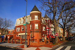
Winter street scene in Truxton Circle
|
|
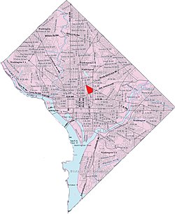
 Truxton Circle within the District of Columbia |
|
| Coordinates: 38°54′40″N 77°00′32″W / 38.911056°N 77.008972°WCoordinates: 38°54′40″N 77°00′32″W / 38.911056°N 77.008972°W | |
| Country | United States |
| District | Washington, D.C. |
| Ward | Ward 5 |
| Government | |
| • Councilmember | Kenyan McDuffie |
Truxton Circle is a neighborhood of Northwest Washington, D.C., bordered by New Jersey Avenue to the west, Florida Avenue to the north, New York Avenue to the south, and North Capitol Street to the east. Politically, it is partially in Ward 5. It is bordered on the north by Bloomingdale and LeDroit Park, to the east by Eckington, to the west by Shaw and Mt. Vernon Square Historic District, and the south by NoMa. Named for a traffic circle that was demolished in 1947, the neighborhood is reclaiming its identity after decades of being presumed nameless.
A traffic circle was constructed at the intersection of Florida Avenue and North Capitol Street around 1900. The circle was named Truxton Circle, after Navy Commodore Thomas Truxtun. A fountain was moved from the intersection of Pennsylvania Avenue and M Street NW to Truxton Circle in 1901.
A police officer conducted traffic at the traffic circle until a traffic light was installed there in 1925.
Because the traffic circle was a site of traffic jams and traffic accidents, it was demolished in 1947 at a cost of $500,000. The adjacent fountain was removed at the same time.
As the traffic circle slipped into history, so did the identity of the predominantly African American neighborhood. It was sometimes lumped in with Shaw, or mistaken for Eckington to the north, or called by the dubious name of "Florida Park," but most residents considered it nameless.
...
Wikipedia
