Trussville, Alabama
| Trussville, Alabama | |
|---|---|
| City | |
| Nickname(s): The Gateway to Happy Living | |
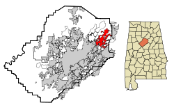
 Location in Jefferson County and the state of Alabama |
|
| Coordinates: 33°37′18″N 86°35′47″W / 33.62167°N 86.59639°W | |
| Country | United States |
| State | Alabama |
| Counties | Jefferson, St. Clair |
| Settled | 1821 |
| Incorporated | 1947 |
| Named for | Warren Truss |
| Government | |
| • Mayor | Buddy Choat |
| Area | |
| • City | 22.3 sq mi (57.6 km2) |
| • Land | 22.2 sq mi (57.4 km2) |
| • Water | 0.1 sq mi (0.2 km2) |
| Elevation | 699 ft (213 m) |
| Population (2015) | |
| • City | 21,023 |
| • Density | 947/sq mi (366/km2) |
| • Metro | 1,145,067 |
| ZIP code | 35173 |
| Area code | 205 |
| FIPS code | 01-76944 |
| GNIS feature ID | 0153729 |
| Website | http://www.trussville.org/ |
Trussville is a city in Jefferson and St. Clair counties in the State of Alabama. It is a suburb of Birmingham and part of the Birmingham-Hoover Metropolitan Statistical Area. Its estimated 2015 population was 21,023.
Trussville has been recognized as one of the most livable cities in the state and country. It was named one of the ten best towns in Alabama for young families, listed among the five best Birmingham suburbs, and included in Money magazine's list of 100 best places to live in America.
Trussville is located at 33°37′18″N 86°35′47″W / 33.62167°N 86.59639°W (33.621623, -86.596404).
According to the United States Census Bureau, the city has a total area of 22.3 square miles (58 km2), of which 22.2 square miles (57 km2) is land and 0.1 square miles (0.26 km2) (0.27%) is water.
The first European settler to establish residence in the area was Warren Truss, who entered the area with his brothers and constructed a grist mill on the Cahaba River in 1821. Truss was a North Carolina man of English descent. Trussville remained an agricultural community until after the Civil War, when the Alabama-Chattanooga Railway was built through the city. By 1886 a blast furnace was built on what is now the site of the new Cahaba Elementary School. Trussville was listed as an incorporated community on the 1890 and 1900 U.S. Census rolls. At some point after 1900 until its reincorporation in 1947, it did not appear on census records.
Much of Trussville's growth and development came from the Cahaba Project, a planned development of over 250 homes constructed by Franklin D. Roosevelt's Government Resettlement Administration during the 1930s. The Cahaba Project was originally planned by staff at the Alabama Polytechnic Institute to be a rural community of small farmsteads raising potatoes and vegetables. By the middle of the decade it was decided to locate the community close enough to Birmingham to commute by public transit, so the site in Trussville was chosen. About 60 existing houses were demolished, with white residents moved to the Roper Hill community and cottages for African-Americans built on a 40-acre tract northwest of the Cahaba Project called "Washington Heights" or, more commonly, "The Forties".
...
Wikipedia
