Truro, South Australia
|
Truro South Australia |
|||||||||||||
|---|---|---|---|---|---|---|---|---|---|---|---|---|---|

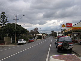
The Sturt Highway, the main street of Truro, (looking west towards the Barossa Valley and Adelaide)
|
|||||||||||||
| Coordinates | 34°24′0″S 139°07′0″E / 34.40000°S 139.11667°ECoordinates: 34°24′0″S 139°07′0″E / 34.40000°S 139.11667°E | ||||||||||||
| Population | 395 (2011 census) | ||||||||||||
| Established | 1847 | ||||||||||||
| Postcode(s) | 5356 | ||||||||||||
| Location | |||||||||||||
| LGA(s) | |||||||||||||
| State electorate(s) | Schubert | ||||||||||||
|
|||||||||||||
Truro (postcode 5356, altitude 311m) is a town in South Australia, 80 km northeast of Adelaide. It is situated in an agricultural and pastoral district on the Sturt Highway, east of the Barossa Valley, where the highway crosses somewhat lofty and rugged parts of the Mount Lofty Ranges. At the 2011 census, Truro had a population of 395.
Truro is in the Mid Murray Council local government area, the South Australian House of Assembly electoral district of Schubert and the Australian House of Representatives Divisions of Barker and Wakefield.
The town was established on Truro Creek (White Hut Creek) in 1848 by John Howard Angas, the son of George Fife Angas who had bought the land in 1842. The survey was conducted by Thomas Burr, assisted by his (eventual) son in law Frederick Sinnett, during a period when both were freed from their usual commitments in order to pursue private contracts.
It is named after the city of Truro in Cornwall, United Kingdom. It is somewhat uncertain whether the name Truro was given by Angas, or the first settlers in the town, but with the Wheal Barton mine nearby, many of those settlers were Cornish miners, so it is quite likely that if they were not the namers of the town, they were certainly the inspiration thereof. The township of Barton was also nearby, however that soon became a part of Truro.
...
Wikipedia

