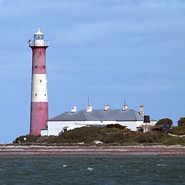
Troubridge Shoals

Troubridge Island Lighthouse
|
|
| Geography | |
|---|---|
| Location | Gulf St Vincent |
| Coordinates | 35°07′04″S 137°49′38″E / 35.11766°S 137.82733°ECoordinates: 35°07′04″S 137°49′38″E / 35.11766°S 137.82733°E |
| Area | 2 ha (4.9 acres) |
| Highest elevation | 5 m (16 ft) |
| Administration | |
|
Australia
|
|
Troubridge Island is an island located in the south west corner of Gulf St Vincent in South Australia near the eastern edge of the Troubridge Shoals off the east coast of Yorke Peninsula about 8 kilometres (5.0 mi) southeast by east of the town of Edithburgh It is notable for being a site of an operating lighthouse from 1856 until 2002 and as a site for a sea bird rookery. Since 1982, the island has been part of the Troubridge Island Conservation Park.
Troubridge Island is located approximately 8 kilometres (5.0 mi) southeast by east of the town of Edithburgh near the eastern edge of the Troubridge Shoals. It is a ‘crest of sand’ which is permanently above high tide and which is stabilised by the presence of vegetation. At high water, the Island had an area of 2 hectares (4.9 acres) and a height of 5 metres (16 feet) as of 1996. At low water, its intertidal zone extends for at least one kilometre (0.62 mi) from its high water mark. The island is most accessible at high tide, when there is sufficient water over the intertidal zone to allow a boat reach the permanently dry land. Since 1988, access to the island has been restricted to these with permits provided by the Department of Environment, Water and Natural Resources.
Most of the 31 plant species recorded from the island are introduced. The vegetation consists of low shrubland dominated by nitre bush, grey saltbush and African boxthorn. Other prominent plants present are tree mallow, sea rocket, marram grass and hairy spinifex.
...
Wikipedia

