Troll gas field
| Troll field | |
|---|---|

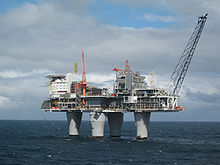
Troll A platform in the Troll gas field
|
|
| Location of Troll field | |
| Country | Norway |
| Region | North Sea |
| Location | North Sea |
| Blocks | 31/2, 31/3, 31/5, 31/6 |
| Offshore/onshore | offshore |
| Coordinates | 60°38′44″N 3°43′35″E / 60.645556°N 3.726389°ECoordinates: 60°38′44″N 3°43′35″E / 60.645556°N 3.726389°E |
| Operator | Statoil |
| Partners | Statoil, Petoro, Royal Dutch Shell, ConocoPhillips, Total S.A. |
| Field history | |
| Discovery | 1979 |
| Start of production | 1995 |
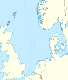
Troll is a natural gas and oil field in the Norwegian sector of the North Sea, one of the biggest in the North Sea, holding 40% of Norway’s gas – it also possesses significant quantities of oil, in thin zones under the gas cap, to the west of the field. The field as a whole consists of the main Troll East and Troll West structures in blocks 31/2, 31/3, 31/5 and 31/6, about 65 kilometres (40 mi) west of Kollsnes, near Bergen. Most of the gas lies in Troll East.
The field is operated by Statoil, which has a 30.58% interest. The other partners are Petoro (56%), Royal Dutch Shell (8.1%), ConocoPhillips (1.62%) and Total S.A. (3.69%).
Gas and oil from the field is extracted via three platforms – Troll A, B and C.
The Troll A platform, based on the Condeep technology, is the tallest structure ever to be moved. Total weight is 656,000 tons, the total height is 472 metres (1,549 ft). The depth is 303 metres (994 ft). This platform came into production in 1996.
The Troll B Platform is a semi-submersible designed by Doris and fabricated from concrete; thought to be the only concrete semisubmersible. This platform came into production in 1995.
The Troll C Platform is a conventional steel hull semi-submersible designed by GVA Consultants. This platform came into production in 1999.
The reservoir is located in three eastward-tilted fault blocks 1500 m subsea and consists of cyclic shallow-marine sandstones from the Fensfjord, middle Heather, Sognefjord and upper Heather formations in the Jurassic Viking Group, and are overlain by Upper Jurassic to Paleocene clays. Located in the eastern margin of the Viking Graben, water depths range from 300–355 m.
...
Wikipedia

