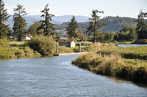
Trask River
| Trask River | |
|
Trask River from Oregon Route 131 bridge at Tillamook
|
|
| Country | United States |
|---|---|
| State | Oregon |
| County | Tillamook County |
| Source | Northern Oregon Coast Range |
| - location | Tillamook State Forest, East of Tillamook |
| - elevation | 281 ft (86 m) |
| - coordinates | 45°26′23″N 123°36′41″W / 45.43972°N 123.61139°W |
| Mouth | Tillamook Bay |
| - elevation | 3 ft (1 m) |
| - coordinates | 45°28′13″N 123°52′57″W / 45.47028°N 123.88250°WCoordinates: 45°28′13″N 123°52′57″W / 45.47028°N 123.88250°W |
| Length | 18 mi (29 km) |
| Basin | 175 sq mi (453 km2) |
| Discharge | for 10.95 miles (17.62 km) from the mouth |
| - average | 989 cu ft/s (28 m3/s) |
| - max | 25,800 cu ft/s (731 m3/s) |
| - min | 49 cu ft/s (1 m3/s) |
The Trask River is in northwestern Oregon in the United States. It drains a mountainous timber-producing area of the Northern Oregon Coast Range west of Portland into Tillamook Bay and the Pacific Ocean. It is one of five rivers—the Tillamook, the Trask, the Wilson, the Kilchis, and the Miami—that flow into the bay.
The main stem of the river is 18 miles (29 km) long from where its two forks join at 45°26′23″N 123°36′41″W / 45.439830°N 123.611505°W. The North Fork, 30 miles (48 km) long, rises in several forks itself in the Tillamook State Forest in western Washington County, west of Forest Grove, Oregon. It flows generally west into eastern Tillamook County. The South Fork, 10 miles (16 km) long, rises in southern Tillamook County at 45°20′56″N 123°39′12″W / 45.3489972°N 123.6534486°W and flows generally northward.
...
Wikipedia


