Transnistria autonomous territorial unit
|
Transnistria autonomous territorial unit |
|
|---|---|

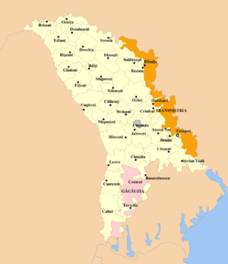
Location and extent of the Transnistria autonomous territorial unit (brown) within Moldova (white).
|
|
| Capital | Tiraspol |
| Languages | |
| Legislature | Supreme Council |
| Autonomous territorial unit of Moldova | |
|
• Created
|
27 July 2005 |
| Area | |
|
• Total
|
4,163 km2 (1,607 sq mi) |
|
• Water (%)
|
2.35 |
| Population | |
|
• 2014 estimate
|
505,153 |
|
• 2004 census
|
555,347 |
|
• Density
|
124.6/km2 (322.7/sq mi) |
| Currency | Transnistrian ruble (PRB) |
|
|
Transnistria autonomous territorial unit, officially The Administrative-Territorial Units of the Left Bank of the Dniester (Romanian: Unitățile Administrativ-Teritoriale din Stînga Nistrului; Russian: Административно-территориальные единицы левобережья Днестра; Ukrainian: Автономне територіальне утворення з особливим правовим статусом Придністров'я) is a formal administrative unit of Moldova established by the Government of Moldova to delineate the territory controlled by the unrecognized Pridnestrovian Moldavian Republic.
After the dissolution of the Soviet Union in 1991, the Transnistria War broke out between the Republic of Moldova and the unrecognized state Pridnestrovian Moldavian Republic on the part of territory of the former Moldavian Soviet Socialist Republic. Since the end of the war there has been territory claimed by Moldova, but controlled by the Pridnestrovian Moldavian Republic. There is also territory claimed by the Pridnestrovian Moldavian Republic, which is controlled by Moldova.
On 22 July 2005, the autonomous territorial unit with special legal status Transnistria was established in Moldova.
Territory of Autonomous territorial unit Transnistria mostly coincides with territory of Pridnestrovian Moldavian Republic, but there are principal differences:
...
Wikipedia
