Transbay Tube

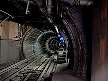
View into the Transbay Tube
|
|
| Overview | |
|---|---|
| Line | |
| Location | San Francisco Bay, California, US |
| Coordinates | Oakland portal: 37°48′32″N 122°18′58″W / 37.80889°N 122.31611°W |
| System | Bay Area Rapid Transit |
| Start | Market Street Subway, San Francisco |
| End | West Oakland Station, Oakland |
| No. of stations | None |
| Operation | |
| Opened | 16 September 1974 |
| Owner | San Francisco Bay Area Rapid Transit District |
| Operator | San Francisco Bay Area Rapid Transit District |
| Character | Rapid transit |
| Technical | |
| Line length | 3.6 mi (5.8 km) |
| No. of tracks | 2 |
| Track gauge | 5 ft 6 in (1,676 mm) Indian gauge |
| Electrified | Third rail, 1000 V DC |
| Highest elevation | Sea level |
| Lowest elevation | 135 ft (41 m) below sea level |
The Transbay Tube is an underwater rail tunnel which carries Bay Area Rapid Transit's four transbay lines under San Francisco Bay between the cities of San Francisco and Oakland in California. The tube is 3.6 miles (5.8 km) long; including the approaches from the nearest stations (one of which is underground), it totals 6 miles (10 km) in length. It has a maximum depth of 135 feet (41 m) below sea level.
The tube was constructed on land, transported to the site, then submerged and fastened to the bottom (mostly by packing the sides with sand and gravel). This immersed tube technique is in contrast to bored tunneling, where rock is removed to leave a passage.
The Tube was the final segment to open in the original BART plan. All BART lines except the Richmond–Fremont line operate through the Transbay Tube, making it one of the busiest sections of the system in terms of passenger and train traffic. During peak commute times, over 28,000 passengers per hour travel through the tunnel with headways as low as 2.5 minutes. BART trains reach their highest speeds in the Tube, almost 80 miles per hour (130 km/h), more than double the average 36 miles per hour (58 km/h) speed in the remainder of the system.
The idea of an underwater rail tunnel traversing San Francisco Bay was suggested by the San Francisco eccentric Emperor Norton in a proclamation that he issued on May 12, 1872. Emperor Norton issued a second proclamation on September 17, 1872, threatening to arrest the city leaders of Oakland and San Francisco for neglecting his earlier proclamation.
Official consideration to the idea was first given in October 1920 by Major General George Washington Goethals, the builder of the Panama Canal. The alignment of Goethals's proposed tube is almost exactly the same as today's Transbay Tube, and called for building on bay mud, which anticipated some of the seismic design aspects of the finished Transbay Tube. Goethals's proposal was estimated to cost up to US$50,000,000 (equivalent to $671,400,000 in 2016). A competing bridge-and-tunnel proposal was advanced in July 1921 by J. Vipond Davies and Ralph Modjeski, closer to the alignment of a proposed Southern Crossing, between Mission Rock and Potrero Point in San Francisco due east to Alameda. Davies and Modjeski were critical of the ventilation issues that would arise from a long combined automobile and rail tunnel, indirectly endorsing the idea of a dedicated tunnel for electric rail traffic. The Davies and Modjeski proposal was joined by twelve other proposed projects to cross the Bay in October 1921, several of which featured rail service through long tunnels.
...
Wikipedia
