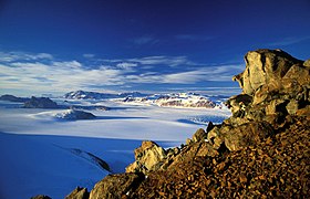
Transantarctic Mountains
| Transantarctic Mountains | |
|---|---|

The Transantarctic Mountains in northern Victoria Land near Cape Roberts
|
|
| Highest point | |
| Peak | Mount Kirkpatrick |
| Elevation | 4,528 m (14,856 ft) |
| Coordinates | 84°20′S 166°25′E / 84.333°S 166.417°E |
| Dimensions | |
| Length | 3,500 km (2,200 mi) |
| Geography | |
| Continent | Antarctica |
| Range coordinates | 85°S 175°W / 85°S 175°WCoordinates: 85°S 175°W / 85°S 175°W |
| Geology | |
| Age of rock | Cenozoic |
The Transantarctic Mountains (abbreviated TAM) comprise a mountain range of uplifted sedimentary rock in Antarctica which extend, with some interruptions, across the continent from Cape Adare in northern Victoria Land to Coats Land. These mountains divide East Antarctica and West Antarctica. They include a number of separately named mountain groups, which are often again subdivided into smaller ranges.
The range was first sighted by James Clark Ross in 1841 at what was later named the Ross Ice Shelf in his honor. It was first crossed during the British National Antarctic Expedition of 1901-1904.
The mountain range stretches between the Ross Sea and the Weddell Sea the entire length of Antarctica, hence the name. With a total length of about 3,500 km, the Transantarctic Mountains are one of the longest mountain ranges on Earth. The 100–300 km wide range forms the boundary between East Antarctica and West Antarctica. The East Antarctic Ice Sheet bounds the TAM along their entire length on the Eastern Hemisphere side, while the Western Hemisphere side of the range is bounded by the Ross Sea (C.Michael Hogan. 2011) in Victoria Land from Cape Adare to McMurdo Sound, the Ross Ice Shelf from McMurdo Sound to near the Scott Glacier, and the West Antarctic Ice Sheet beyond.
...
Wikipedia

