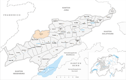
Tramelan
| Tramelan | ||
|---|---|---|

Tramelan
|
||
|
||
| Coordinates: 47°13′N 7°6′E / 47.217°N 7.100°ECoordinates: 47°13′N 7°6′E / 47.217°N 7.100°E | ||
| Country | Switzerland | |
| Canton | Bern | |
| District | Jura bernois | |
| Government | ||
| • Executive |
Conseil municipal with 7 members |
|
| • Mayor | Maire | |
| • Parliament |
Conseil général with 37 members |
|
| Area | ||
| • Total | 24.82 km2 (9.58 sq mi) | |
| Elevation | 900 m (3,000 ft) | |
| Population (Dec 2015) | ||
| • Total | 4,417 | |
| • Density | 180/km2 (460/sq mi) | |
| Postal code | 2720 | |
| SFOS number | 0446 | |
| Surrounded by | Mont-Tramelan, Corgémont, Tavannes, Saicourt, Les Genevez, Montfaucon, Le Bémont, Saignelégier, La Chaux-des-Breuleux | |
| Website |
www SFSO statistics |
|
Tramelan is a municipality in the Jura bernois administrative district in the canton of Bern in Switzerland. It is located in the French-speaking Bernese Jura (Jura Bernois).
Tramelan is first mentioned in 1179 as Trameleins. The municipality was formerly known by its German name Tremlingen, however, that name is no longer used.
During the Middle Ages the collegiate church of Saint-Imier was the major landholder in Tramelan. Politically, the villages were part of the seigniory of Erguel under the Prince-Bishop of Basel. From the 13th century until the mid 15th century there was a local noble family that ruled in Tramelan, probably as a fief under the Prince-Bishop. The village of Tramelan-le-Bas was first mentioned in 1334 while Tramelan-le-Haut appears in documents in 1358. In 1481, 1543 and 1581 the two villages met together to officially define their mutual border. In 1686, immigrants from Neuchâtel established the village of Mont-Tramelan.
After the 1797 French victory and the Treaty of Campo Formio, Tramelan became part of the French Département of Mont-Terrible. Three years later, in 1800 it became part of the Département of Haut-Rhin. After Napoleon's defeat and the Congress of Vienna, Tramelan was assigned to the Canton of Bern in 1815.
...
Wikipedia


