Toulon–Hyères Airport
|
Toulon–Hyères Airport Aéroport de Toulon – Hyères |
|||||||||||||||
|---|---|---|---|---|---|---|---|---|---|---|---|---|---|---|---|
 |
|||||||||||||||
| Summary | |||||||||||||||
| Airport type | Public / Military | ||||||||||||||
| Operator | CCI Du Var | ||||||||||||||
| Serves | Toulon, France | ||||||||||||||
| Location | Hyères | ||||||||||||||
| Elevation AMSL | 13 ft / 4 m | ||||||||||||||
| Coordinates | 43°05′50″N 006°08′46″E / 43.09722°N 6.14611°ECoordinates: 43°05′50″N 006°08′46″E / 43.09722°N 6.14611°E | ||||||||||||||
| Website | toulon-hyeres |
||||||||||||||
| Maps | |||||||||||||||
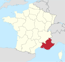
 Provence-Alpes-Côte d'Azur in France |
|||||||||||||||
| Location in Provence-Alpes-Côte d'Azur region | |||||||||||||||
| Runways | |||||||||||||||
|
|||||||||||||||
| Statistics (2014) | |||||||||||||||
|
|||||||||||||||
|
Source: AIP France
|
|||||||||||||||
| Passengers | 550,768 |
|---|---|
| Passenger Change 13-14 |
|
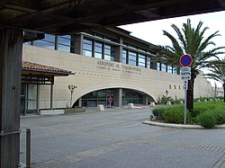
Toulon–Hyères Airport (French: Aéroport de Toulon – Hyères, IATA: TLN, ICAO: LFTH) is an airport serving Toulon, a commune in the Var department of the Provence-Alpes-Côte d'Azur region in France. The airport is located 3 kilometres (2 mi) southeast of Hyères, and 19 kilometres (12 mi) east of Toulon. It is also known as Hyères Le Palyvestre Airport. In 2010, the airport served 502,974 passengers.. The airport opened in 1966.
The airport resides at an elevation of 13 feet (4 m) above mean sea level. It has two paved runways: 05/23 measures 2,120 by 45 metres (6,955 ft × 148 ft) and 13/31 is 1,902 by 46 metres (6,240 ft × 151 ft).
This airport is shared with the French Naval Aviation (Aéronautique navale), as Hyeres Naval Air Base (la base d'aviation navale d'Hyères). Several squadrons of helicopters and fixed-wing aircraft are based on the south-western side of the airport.
...
Wikipedia

