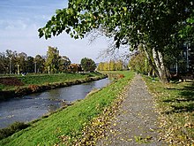
Torysa River
| Torysa River | |
|---|---|

Torysa river in Prešov
|
|
| Country | Slovakia |
| Basin features | |
| Main source | Levoča Mountains |
| River mouth |
Hornád near Nižná Hutka 48°38′29″N 21°21′30″E / 48.6414°N 21.3582°ECoordinates: 48°38′29″N 21°21′30″E / 48.6414°N 21.3582°E |
| Progression | Hornád→ Sajó→ Tisza→ Danube→ Black Sea |
| Basin size | 1,349 km2 (521 sq mi) |
| Physical characteristics | |
| Length | 129 km (80 mi) |
| Discharge |
|
The Torysa (Slovak pronunciation: [ˈtorisa]) is a 129 km (80 mi) long river in eastern Slovakia. Its source is in the Levoča Mountains and it flows through the towns of: Lipany, Sabinov, Veľký Šariš, Prešov, and into the Hornád river near Nižná Hutka, southeast of Košice.
...
Wikipedia
