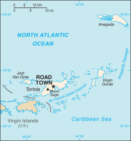
Tortola, British Virgin Islands

Tortola is the largest of the British Virgin Islands
|
|
 |
|
| Geography | |
|---|---|
| Location | Atlantic Ocean |
| Coordinates | 18°25′24″N 64°37′05″W / 18.42333°N 64.61806°W |
| Archipelago | Virgin Islands |
| Area | 55.7 km2 (21.5 sq mi) |
| Length | 19 km (11.8 mi) |
| Width | 5 km (3.1 mi) |
| Highest elevation | 530 m (1,740 ft) |
| Highest point | Mount Sage |
| Administration | |
|
United Kingdom
|
|
| British Overseas Territory | British Virgin Islands |
| Largest settlement | Road Town (pop. 9,400) |
| Demographics | |
| Demonym | Tortolian |
| Population | 23,908 |
| Pop. density | 429.23 /km2 (1,111.7 /sq mi) |
Tortola /tɔːrˈtoʊlə/ is the largest and most populated of the British Virgin Islands, a group of islands that form part of the archipelago of the Virgin Islands. It has a surface area of 55.7 square kilometres (21.5 square miles) with a total population of 23,908, with 9,400 residents in Road Town. Mount Sage is its highest point at 530 metres (1,740 feet) above sea level.
Although the British Virgin Islands (BVI) are under the British flag, it uses the US dollar as its official currency due to its proximity to and frequent trade with the US Virgin Islands and Puerto Rico. The island is home to many offshore companies that do business worldwide. Financial services are a major part of the country's economy.
On 7 September 2017, the British Virgin Islands were extensively damaged by Hurricane Irma. The most severe destruction was on Tortola. News reports over the next day or two described the situation as "devastation".
Local tradition recounts that Christopher Columbus named the island Tórtola, meaning "turtle dove" in Spanish. In fact, Columbus named the island Santa Ana. Dutch colonists called it Ter Tholen, after a coastal island that is part of the Netherlands. When the British took over, the name evolved to Tortola.
...
Wikipedia
