Torksey
| Torksey | |
|---|---|
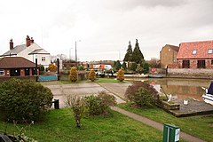
 Torksey Lock slipway |
|
| Torksey shown within Lincolnshire | |
| Population | 875 (2011) |
| OS grid reference | SK837786 |
| • London | 130 mi (210 km) S |
| District | |
| Shire county | |
| Region | |
| Country | England |
| Sovereign state | United Kingdom |
| Post town | LINCOLN |
| Postcode district | LN1 |
| Police | Lincolnshire |
| Fire | Lincolnshire |
| Ambulance | East Midlands |
| EU Parliament | East Midlands |
| UK Parliament | |
Torksey is a small village in the West Lindsey district of Lincolnshire, England. The population of the civil parish at the 2011 census was 875. It is situated on the A156 road, 7 miles (11 km) south of Gainsborough and 9 miles (14 km) north-west of the city of Lincoln, and on the eastern bank of the tidal River Trent, which here forms the boundary with Nottinghamshire.
It is notable historically as the site of a Roman canal, a major Viking camp, the late medieval Torksey Castle and a Victorian railway bridge, Torksey Viaduct.
Foss Dyke, a Roman canal constructed in or about the 2nd Century, joins the River Trent by way of a series of lock-gates about half a mile (800 m) south of the village.
During the 9th Century, Torksey was part of the Anglo-Saxon Kingdom of Lindsey. In the late 860s, a Viking invasion force known to the English as the "Great Heathen Army" conquered eastern England. In 871–2, the Vikings established a winter camp in London, but returned to Northumbria soon afterwards, following a rebellion against their rule. During 872–3, the Great Heathen Army established its winter quarters at Torksey.
The now Grade I listed 16th-century Torksey Castle was destroyed in August 1645 during the English Civil War; its remains are on the river side of the dike which separates it from dry land.
...
Wikipedia

